Explore
 Shop
Shop About
About Search
Overview Index
Camps Bay Beach
-33.950000°, 18.383333° - Cape Town, South AfricaWaves break on the rocks by Camps Bay Beach — a beautiful white-sand beach in Camps Bay, a suburb of Cape Town, South Africa. In the summer, many South Africans and tourists flock to this beautiful area of the city.
Maxar Technologies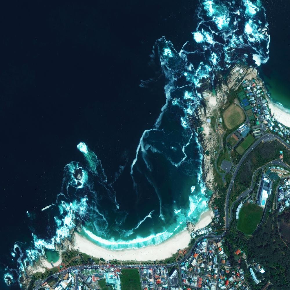
Canyon Lake
33.681444°, -117.250389° - 33.681444°, -117.250389°Canyon Lake is a city and gated community in southern California, with a population of slightly more than 11,000 people. Constructed as a master-planned community in 1968, it is one of just five gated cities in the state. In 2006, it was featured in “United Gates of America,” a BBC documentary that explored why people live in gated communities and what effects it has on them.
Nearmap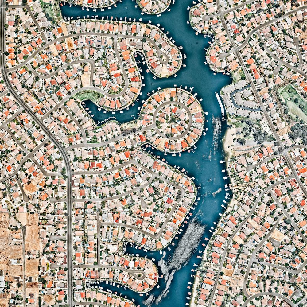
Cape Cod
41.797291°, -70.868541° - Cape Cod, Massachusetts, USACape Cod is a hook-shaped peninsula that extends into the Atlantic Ocean off southeastern Massachusetts, USA. The 15 towns on the cape are a popular summer destination with quaint villages, seafood shacks, lighthouses, and many beaches. The three towns at the northernmost tip of the cape — Wellfleet, Truro, and Provincetown — are visible in this Overview.
Maxar Technologies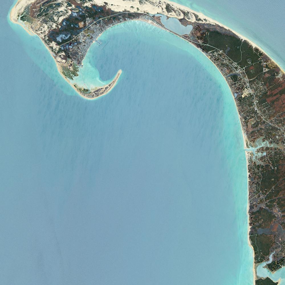
Cape Coral
26.604391°, -81.000000° - Cape Coral, FloridaBecause many cities in the state of Florida contain master-planned communities, often built on top of waterways in the latter half of the twentieth century, there are a number of intricate designs that are visible from the Overview perspective. Here is one particular development in Cape Coral, a city with a population of 165,831 people.
Maxar Technologies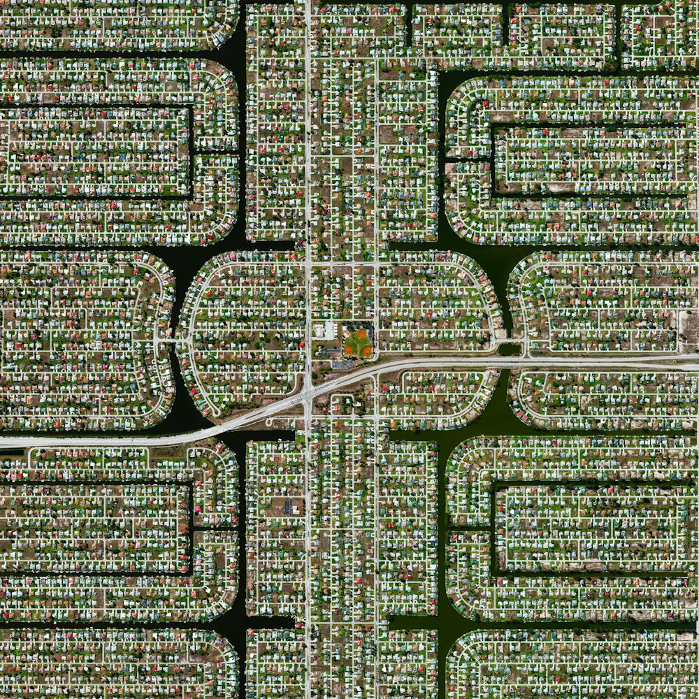
Cape Town
-33.925278°, 18.423889° - Cape Town, South AfricaCape Town is a port city on South Africa’s southwest coast. The city’s geography is influenced by the surrounding Table Mountain, the Durbanville Hills, and the expansive lowland region known as the Cape Flats. These geographic features divide the city into several commonly known suburbs, many of which developed simultaneously and share common attributes of language and culture. This unique blend has made Cape Town one of the most multicultural cities in the world, attracting tourists, immigrants, and expats to South Africa.
Maxar Technologies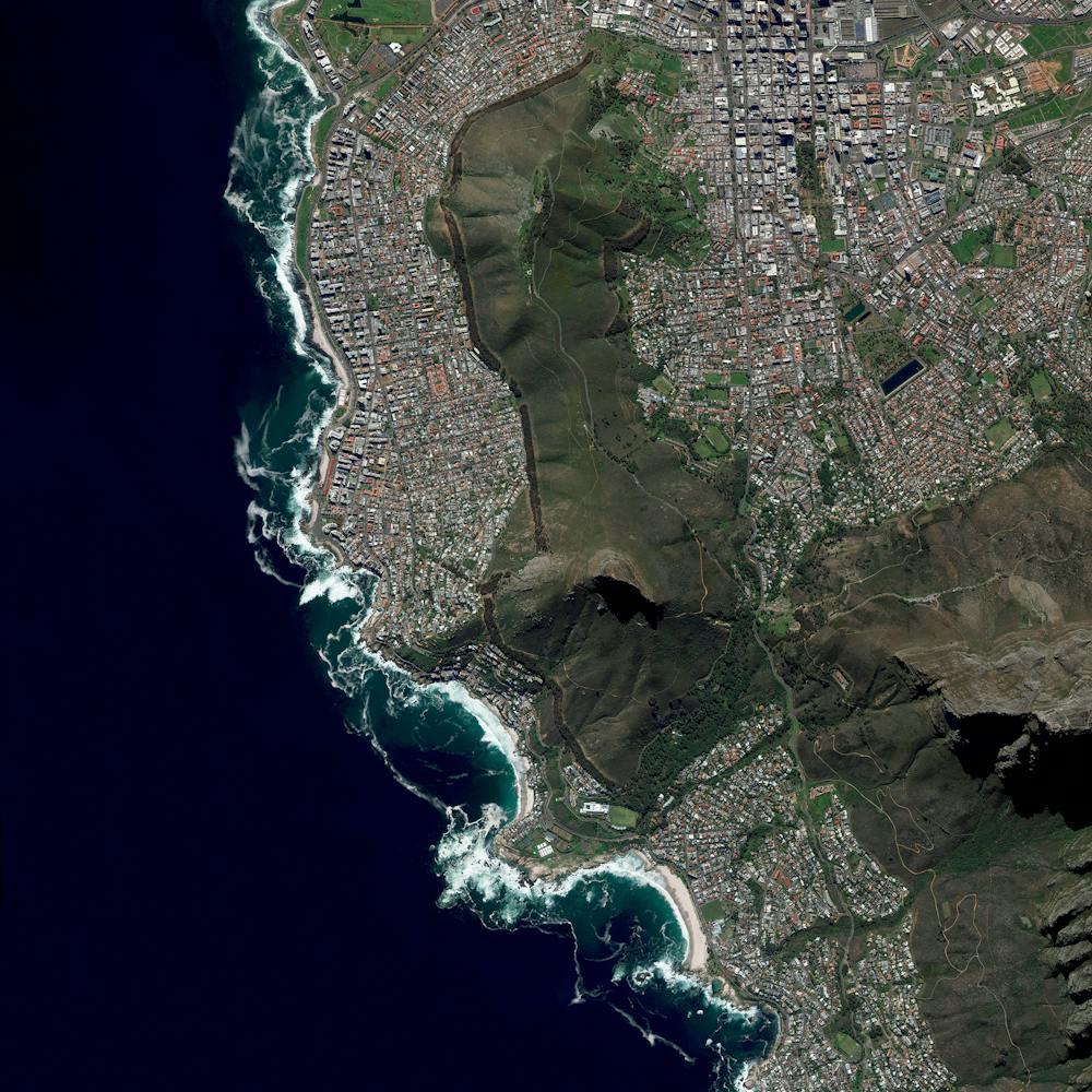
Capital Hill
-35.308056°, 149.124444° - Canberra, AustraliaThe construction of Parliament House in Canberra, Australia involved the removal of the top half of Capital Hill (the mound on which the structure was built). After the project was completed, much of the displaced earth was replaced on top of the building where a lush, green lawn now grows. While much of Canberra was designed by by Walter Burley Griffin in 1913, this specific complex opened in 1988, is designed to look like two boomerangs, and contains approximately 4,400 rooms.
Maxar Technologies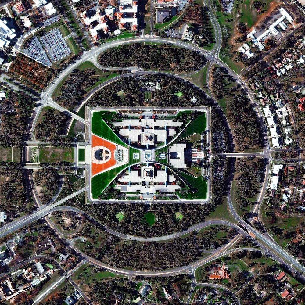
Capitol Hill
38.894833°, -76.994500° - Washington D.C., USACapitol Hill is the largest and one of the oldest residential neighborhoods in Washington, D.C. With roughly 35,000 people in just under 2 square miles (5 sq. km), it is also one of the most densely populated communities in the District. Many of Capitol Hill’s residents live in rowhouses of different architectural variety, including 19th century manor houses, Federal townhouses, ornate Italianate bracketed houses, and others.
Nearmap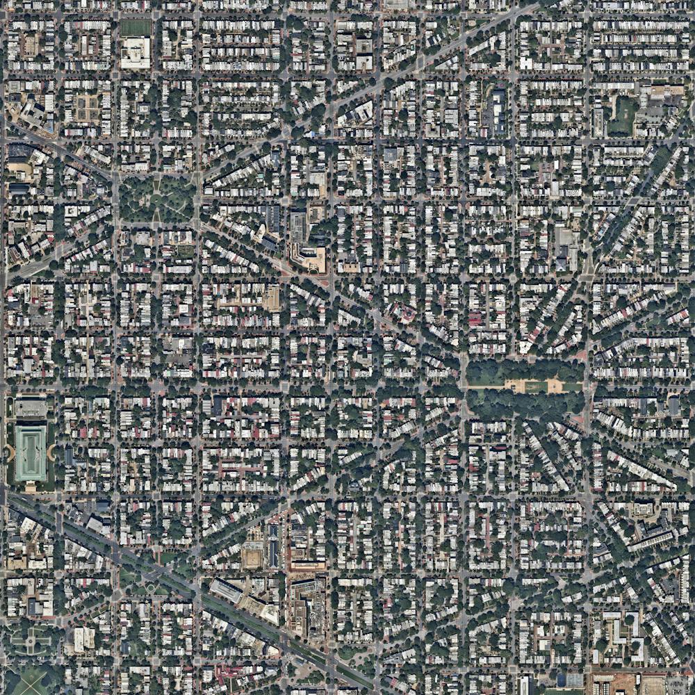
Car terminal
37.908562°, -122.367247° - Richmond, California, USACars are unloaded and parked at an automobile terminal in Richmond, California, USA. In 2015, 17.5 million cars and light trucks were sold in the United States, raising the total number of registered vehicles in the country to roughly 253 million.
Nearmap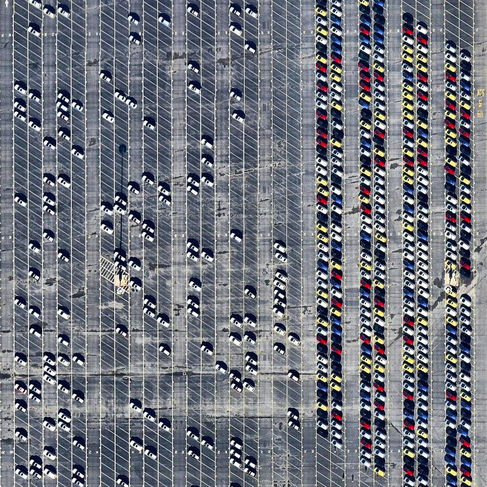
Caracas
10.500000°, -66.916667° - Caracas, VenezuelaCaracas is the capital and largest city in Venezuela, with more than three million residents. In recent months, plummeting oil prices combined with a significant drought has created a dire situation in cities across the nation. Four hour blackouts are now a regular occurrence and some regions go without power for days at a time. Most supermarkets have almost no food to sell, hospitals have no medicine, and crime is rampant and escalating. We hope this post continues to raise awareness for the crisis in Venezuela and that the situation on the ground improves in the very near future.
Maxar Technologies
Carrara Marble
44.100989°, 10.131797° - Carrara, ItalyMarble quarriers are visible in Carrara, Italy. The blue-grey marble that is extracted here is widely used in sculpture like Michelangelo’s David and in building decor like that of The Pantheon. With more than 650 active or abandoned quarry sites, more marble has been extracted here than any other place on earth. /// Created by @dailyoverview, source imagery: @maxartechnologies
Maxar Technologies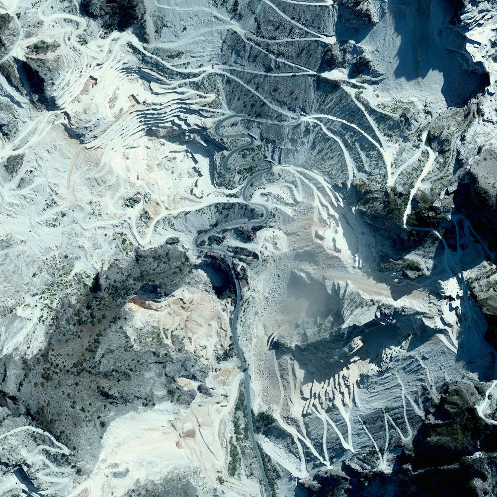
Cars At Philadelphia Navy Yard
39.894037°, -75.179375° - Philadelphia, Pennsylvania, USAThousands of automobiles fill a large lot near the Philadelphia Navy Yard in southern Philadelphia, Pennsylvania. Since 2010, when Hyundai and Kia Motors moved their import businesses to the city, several large lots like this have popped up to accommodate an influx of new vehicles. At least 120,000 vehicles a year have arrived at the Port of Philadelphia since 2011, and more than 155,000 were delivered in 2015.
Nearmap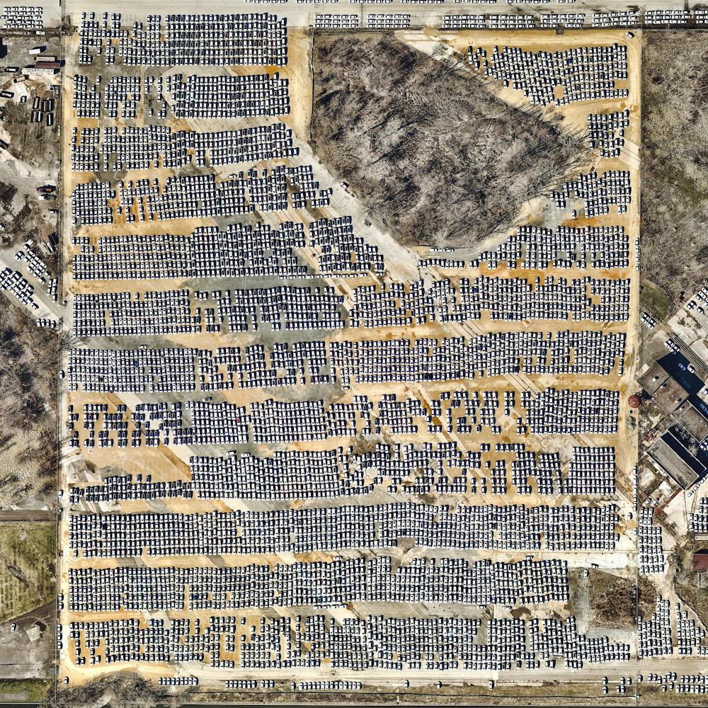
Casablanca
33.548213°, -7.574324° - Casablanca, MoroccoCasablanca is the largest city in Morocco with roughly 4 million residents, accounting for 11% of the entire country's population. Many officials believe these figures are underestimated and the total population is actually somewhere between 5 and 6 million. This recent surge has occurred because severe droughts have forced many Moroccans to move into urban areas to find new forms of work. The Cite Djemaa neighborhood, located in the southeast of the city, is seen here.
Maxar Technologies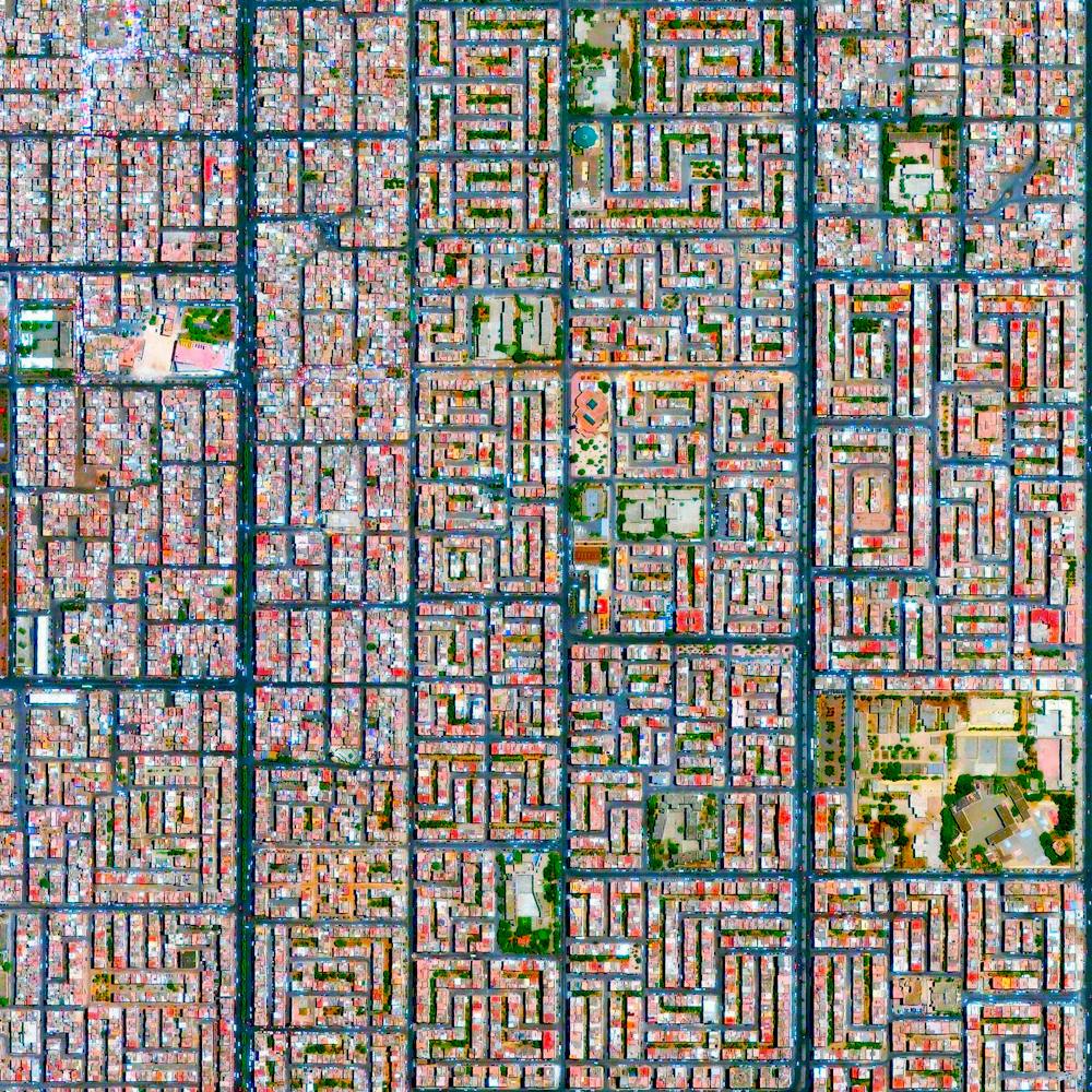
Cattle feedlot
34.715428°, -102.507400° - Summerfield, Texas, USACattle are visible at a feedlot in Summerfield, Texas, USA. Once the animals reach a weight of 650 pounds, they are moved to these facilities and placed on a strict diet of specialized animal feed. Over the next three to four months, the cows gain up to 400 more pounds before they are shipped off to slaughter. The lagoon seen at the top of this feedlot gets is glowing color from a high concentration of manure and chemicals.
Maxar Technologies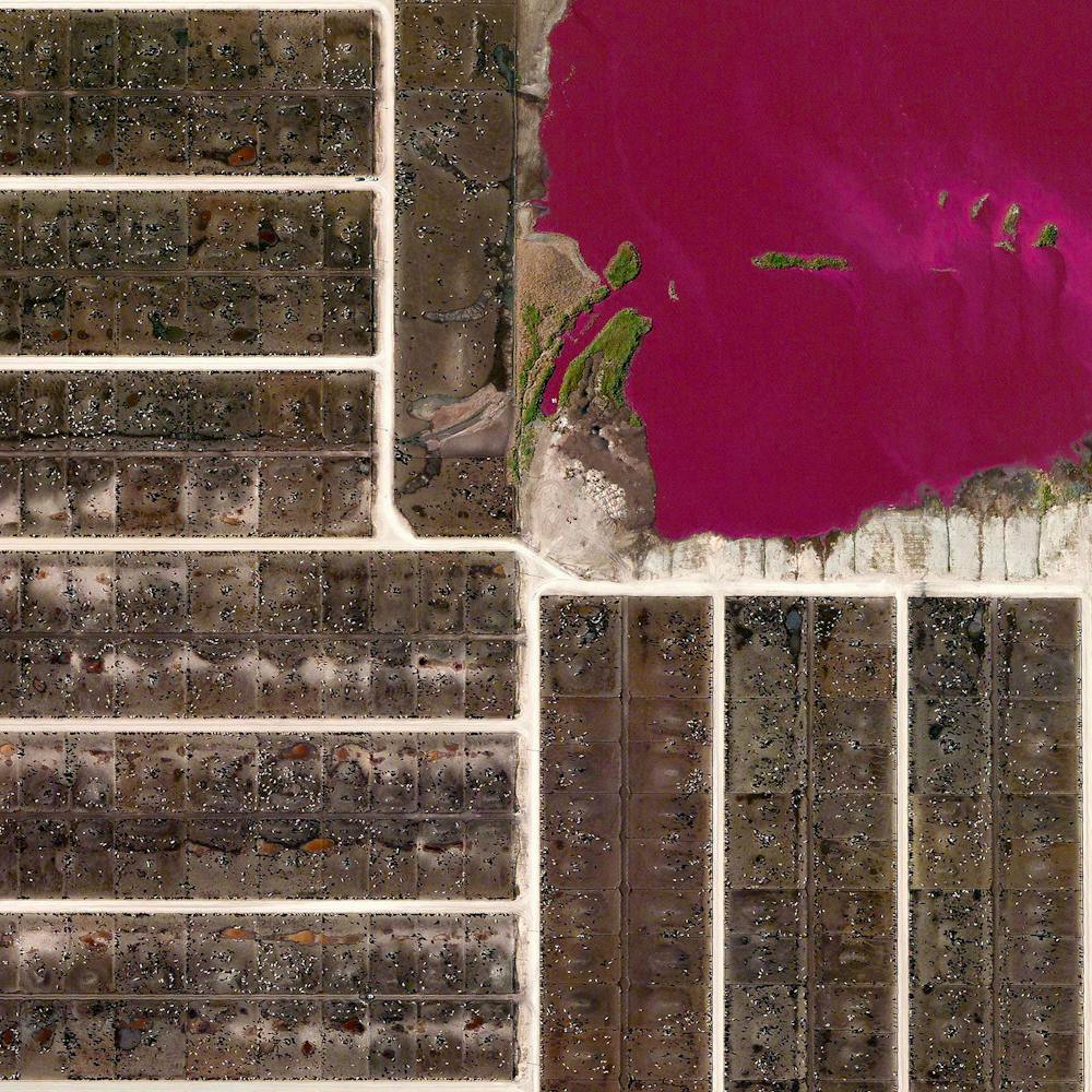
Ceilândia
-15.819444°, -48.110278° - Ceilândia, BrazilCeilândia is the most populous administrative region in the Federal District of Brazil, with about 489,000 inhabitants. Located just west of Brasília, it was created in the 1970s to prevent overcrowded shanty towns from developing in the capital city. With nearly half of Ceilândia's residents hailing from the Northeast — or "Nordeste" — Region, the city has a vibrant culture with unique styles of dance, music and cuisine.
Maxar Technologies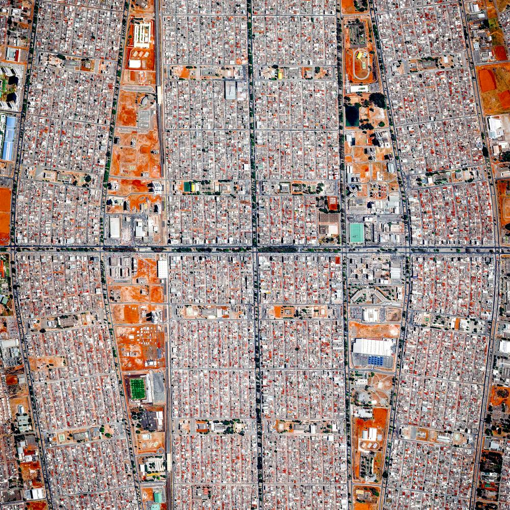
Center-pivot irrigation
30.089890°, 38.271807° - Wadi As-Sirhan Basin, Saudi ArabiaCenter pivot irrigation is used throughout the Wadi As-Sirhan Basin of Saudi Arabia. Water is mined from depths as great as one kilometer (~3,000 ft), pumped to the surface, and evenly distributed by sprinklers that rotate 360 degrees. Spurred by a government effort to strengthen its agriculture sector, cultivated land in Saudi Arabia grew from 400,000 acres in 1976 to more than 8 million acres by 1993. For a sense of scale, the total area shown in this Overview is approximately fifty square miles (32,000 acres).
Maxar Technologies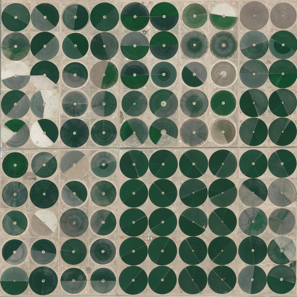
Central de Abasto
19.373908°, -99.088439° - 19.373908°, -99.088439°Thousands of trucks and cars surround the Central de Abasto — Mexico City’s largest wholesale market for produce and other foodstuffs. The market serves more than 300,000 people and handles over 30,000 tons of merchandise each day — representing 80% of the consumption of the Mexico City metropolitan area.
Maxar Technologies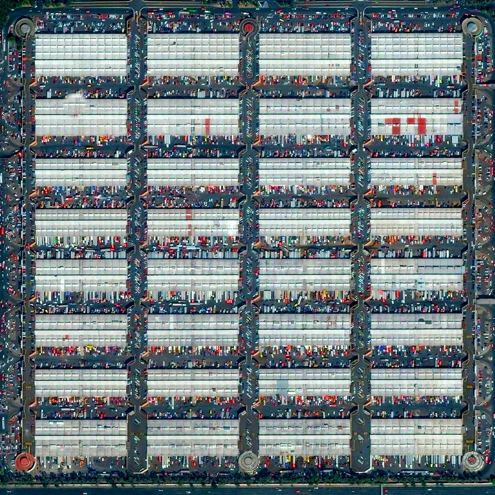
Central Park
40.782222°, -73.965278° - New York, New York, USAThis Overview captures Central Park in New York City. Located in the middle of Manhattan, the park spans 843 acres — or 6% of the borough. One of the most influential innovations in the park's design was its "separate circulation" systems for pedestrians, horseback riders, and automobiles. This concealed "crosstown" commercial traffic in sunken roadways (known as "transverses" today), and densely planted shrub belts in order to maintain a rustic ambiance.
Maxar Technologies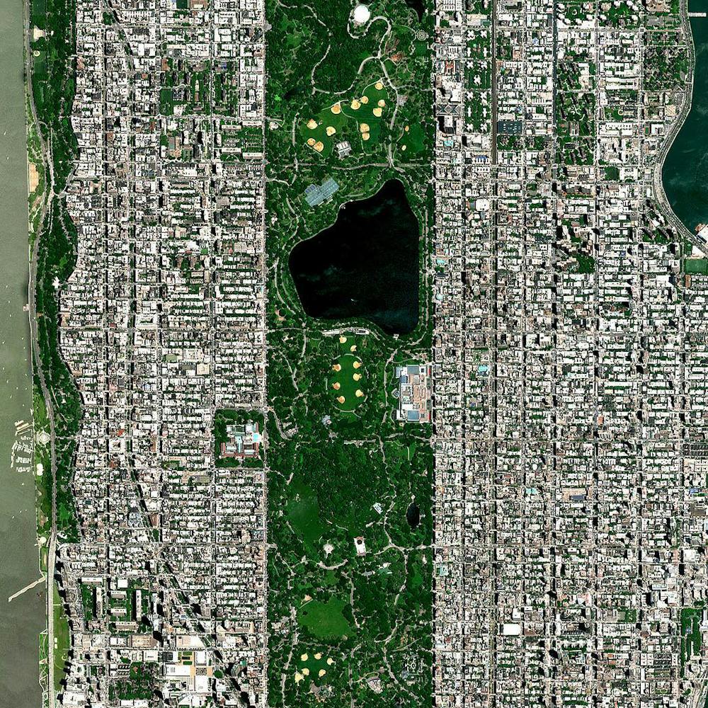
Channel Tunnel
50.931745°, 1.824168° - Calais, FranceTrucks sit by the entrance of the Channel Tunnel in Calais, France. in an effort to get to Britain - 31.4 miles away via the underwater passage. This is the latest incident in an ongoing crisis in Europe where an estimated 100,000 migrants have entered the continent to flee violence and poverty in neighboring regions.
Maxar Technologies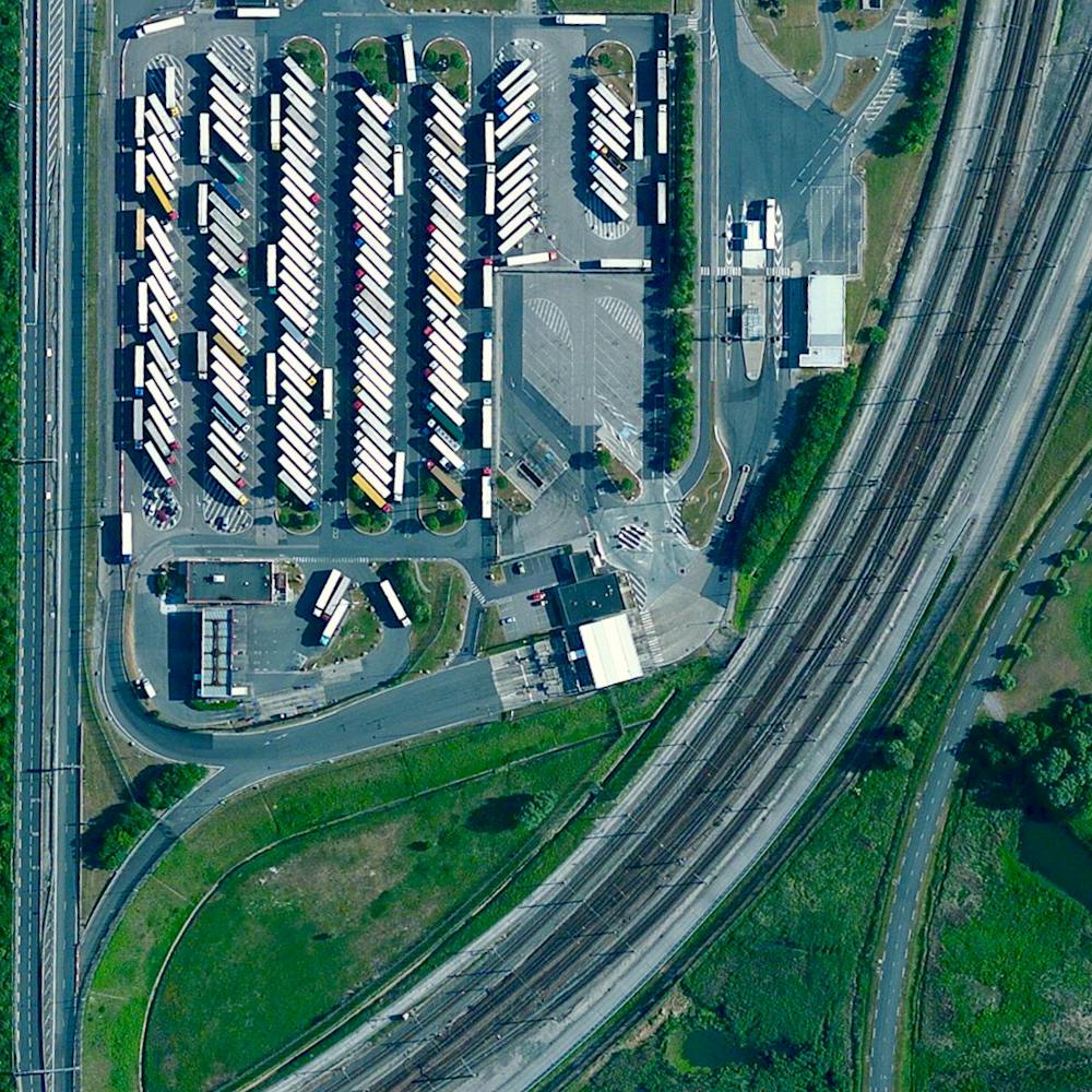
Chausey
48.870278°, -1.822500° - Normandy, FranceChausey is a group of small islands, islets and rocks in the English Channel, off the coast of Normandy, France. The archipelago comprises 365 islands at low tide, but only 52 island at high tide. Grande-Île, the main island, is 0.93 miles (1.5 km) long and 0.3 miles (0.5 km) wide at its widest. It is the only inhabited island in the Chausey group, with roughly 30 residents.
Maxar Technologies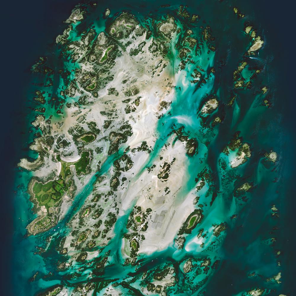
Chicago
41.888889°, -87.626667° - Chicago, Illinois, USAChicago, Illinois, is the third most populous city in the United States, with more than 2.7 million residents. This Overview shows the Chicago River flowing through the city center, dividing The Loop (left) and Near North Side (right) communities. Many of the city’s prominent skyscrapers can be seen from this perspective, including the Trump International Hotel and Tower, the Aon Center, and Grant Thornton Tower.
Nearmap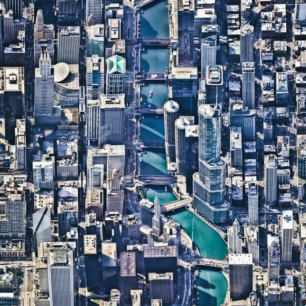
Chicago Midway International Airport (MDW)
41.786775°, -87.752188° - Chicago, Illinois, USAChicago Midway International Airport is a major commercial airport on the southwest side of Chicago, Illinois. It was the city's primary airport from the time it opened in 1927 until 1955, when O'Hare International Airport was opened roughly 20 miles (32 km) to its north. Located on one square mile (2.59 sq. km), Midway remains the second-busiest airport in the state of Illinois, having served 22 million passengers in 2018.
Maxar Technologies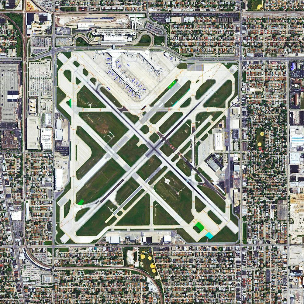
Chicago O'Hare International Airport (ORD)
41.978806°, -87.902833° - Chicago, Illinois, USAO'Hare International Airport — located in the far northwest corner of Chicago, Illinois — is the sixth-busiest passenger airport in the world. It provides direct flights to 217 destinations in North America, South America, Asia, Africa and Europe. In 2017, O'Hare served more than 79.8 million passengers.
Nearmap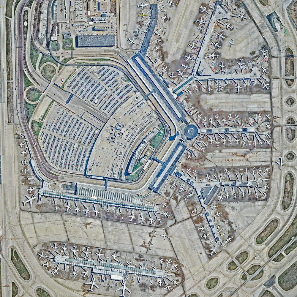
Chicago Polar Vortex
41.833647°, -87.872390° - Chicago, Illinois, USACheck out this amazing Overview of Chicago, Illinois, and Lake Michigan during last week's polar vortex. Captured Thursday by the European Space Agency's Sentinel-2 satellite, it shows the entire city covered in snow with massive chunks of lake ice floating offshore. Chicago finished off the month of January with 13 consecutive days of snow and some of its coldest temperatures in more than three decades.
ESA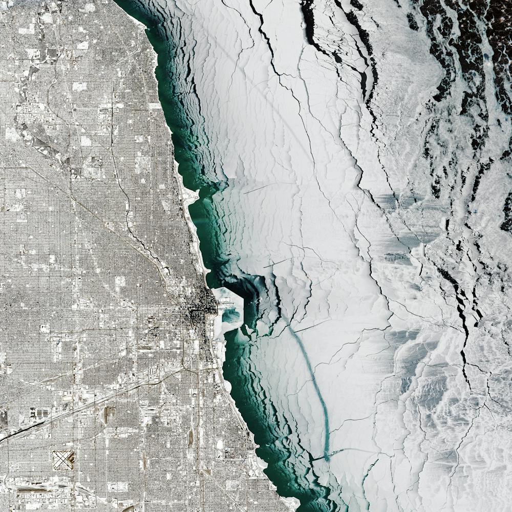
Chicago Tractor-Trailer Hub
41.750750°, -87.878611° - Hodgkins, Illinois, USATrailers are docked and loaded at the Chicago Area Consolidation Hub, a package sorting facility in Hodgkins, Illinois. This 1.5 million square foot (139,355 sq. m) facility is owned by the United Parcel Service (UPS) and handles packages traveling throughout the United States and world. Roughly 1.5 million packages pass through its more than 65 miles (105 km) of conveyor belts every day.
Nearmap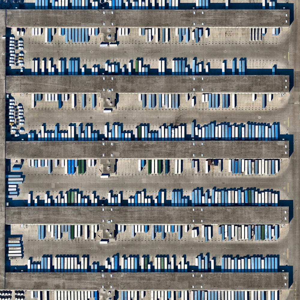
Chicama, Peru
-8.005722°, -79.188250° - Chicama, PeruWaves roll in to Chicama, Peru. This area is well known for having one of the longest surfs in the world, especially at “The Point,” a spot where you can allegedly surf a single wave for slightly more than a mile (2 km) if conditions are right.
Maxar Technologies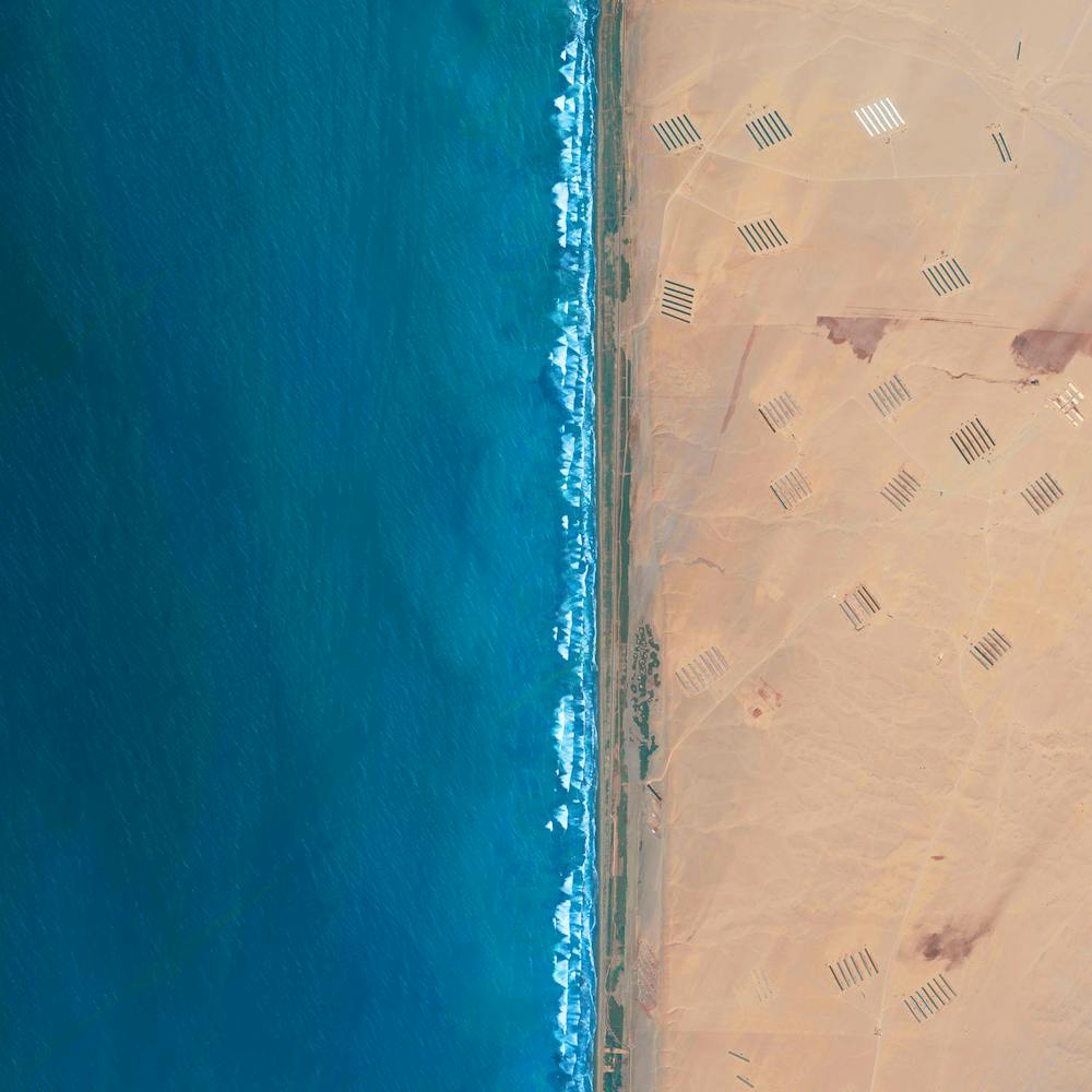
Chilean Coast Range
-24.737494°, -70.565057° - ChileCheck out this amazing Overview of the Chilean Coast Range, which runs along the Pacific coast of Chile. It extends 1,900 miles (3,100 km) from north to south, and this image captures a section near the city of Antofagasta. The highest point in the Chilean Coast Range is Cerro Vicuña Mackenna, which peaks at 10,217 feet (3,114 m).
Maxar Technologies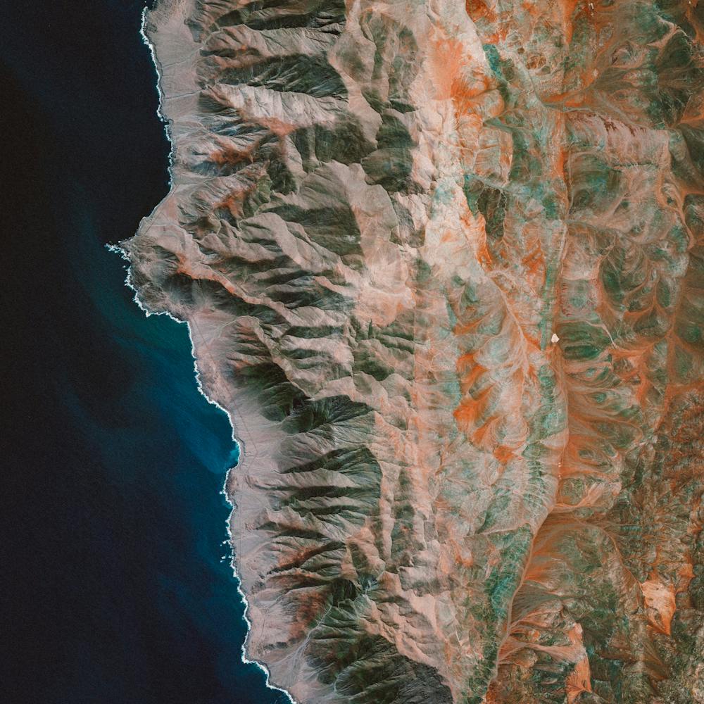
Chilean Protests
-33.437000°, -70.634411° - -33.437000°, -70.634411°On Friday, more than a million people gathered at a peaceful protest in Santiago, Chile, calling for social reform. Originally sparked by an increase in metro fares, the movement has grown over the past several days to address broader issues of living costs and inequality. More than 20 people have been killed since the protests began, and today Chilean President Sebastián Piñera removed eight members of his cabinet in an attempt to quell protests.
Maria Gracia Subercaseaux
Chimalhuacán
19.435063°, -98.968517° - Chimalhuacán, MexicoChimalhuacán is a city with more than 600,000 residents in the eastern part of the State of Mexico, Mexico. The colorful stretch of road seen across the bottom of this Overview is a open-air market known as a tianguis. Here, merchants cover their stalls with vibrant canopies to protect themselves from harsh sun and inclement weather.
Maxar Technologies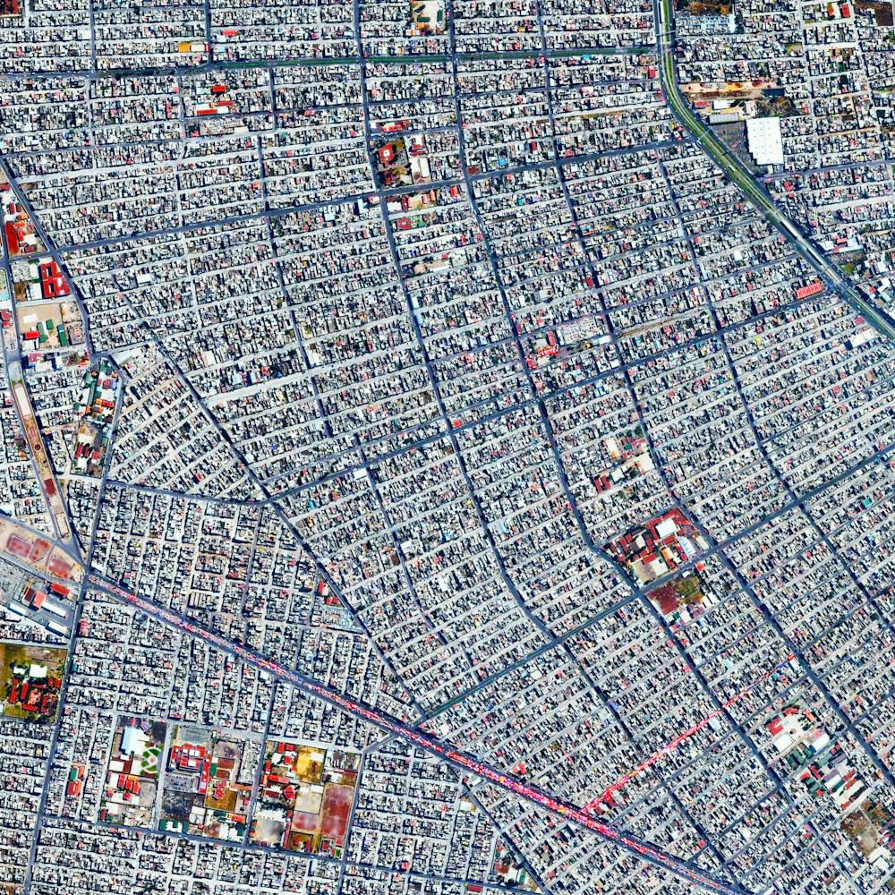
Chinese Floating Solar Farm
32.580123°, 116.589000° - Huainan, ChinaSolar panels sitting atop a man-made lake in Huainan, China, make up the world’s largest floating solar farm. Sungrow Huainan Solar Farm is capable of producing enough electricity to power 15,000 homes and floats above an area formerly used for coal mining.
Maxar Technologies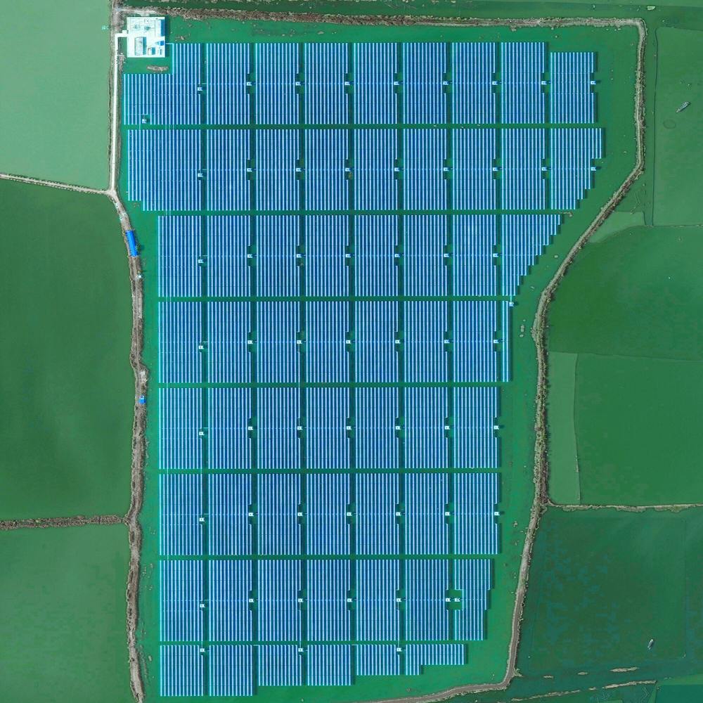
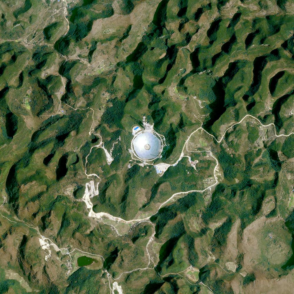
Chinese Radio Telescope
25.652920°, 106.856580° - 25.652920°, 106.856580°The Five-hundred-meter Aperture Spherical Telescope is a radio telescope in the limestone hills of China’s Guizhou province. With a dish 1,600 feet (500 m) in diameter, it is the world’s largest filled-aperture radio telescope and the second-largest single-dish aperture, behind Russia’s RATAN-600.
Maxar Technologies