Explore
 Shop
Shop About
About Search
Overview Index
Kawah Ijen
-8.058000°, 114.242000° - Java, IndonesiaKawah Ijen is a stratovolcano in the East Java Province of Indonesia. It has a 0.6-mile-wide (1 km) turquoise-colored acidic crater lake, which is the site of a major sulfur mining operation. At night, when sulfuric gases make contact with fresh air, electric blue flames can be seen rising from volcano up to 16 feet (5 m) high.
Maxar Technologies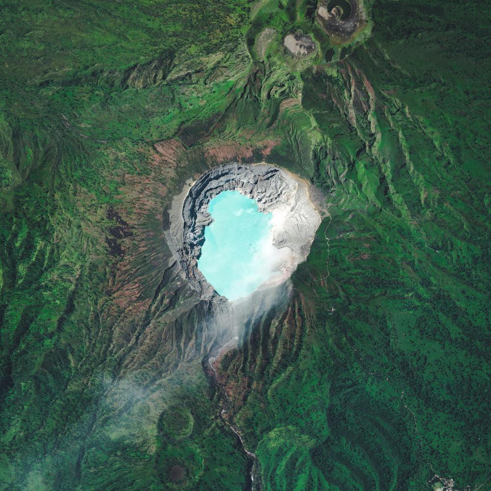
Kensico Reservoir Bridge
41.098889°, -73.745194° - Valhalla, New York, USAA bridge crosses the Kensico Reservoir in the town of Valhalla, New York. Located about 15 miles (24 km) north of New York City, the reservoir stores waters received from the Catskill Mountains and provides a site for fishing and boating recreation. With an average depth of nearly 44 feet (13.5 m) and a maximum depth of 120 feet (37 m), it can hold 30 billion gallons (113 billion liters) of water.
Nearmap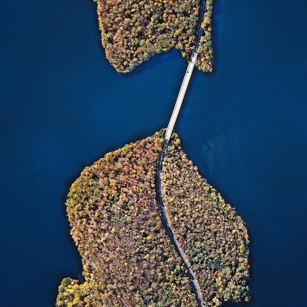
Key West
24.564635°, -81.815648° - Key West, Florida, USAKey West is an island and city in the Straits of Florida, USA. It is the southernmost city in the contiguous United States and the westernmost island connected by highway in the Florida Keys. The island, which is about 4 miles (6.4 km) long and 1 mile (1.6 km) wide, has a population of approximately 25,000 and was visited by 2.25 million tourists in 2016.
Nearmap
Khalifa International Stadium
25.263664°, 51.448078° - Doha, QatarKhalifa International Stadium is a massive sports complex in Doha, Qatar. The facility is currently undergoing a massive renovation and expansion in advance of the 2022 World Cup, which will be hosted by the Qataris. The blue structure adjacent to the stadium is Aspire Academy, a youth sports school.
Maxar Technologies
Khawr Abd Allah Estuary Overturned Boat
30.001528°, 47.995083° - Umm Qasr, IraqA large boat lies overturned in the Khawr Abd Allah estuary, near the city of Umm Qasr in southern Iraq. Since this waterway is close to Iraq’s borders with Kuwait and Iran, it has played an important role in regional conflicts, such as the Iran-Iraq War and the First Gulf War.
Maxar Technologies
King River
-42.190139°, 145.429806° - Tasmania, AustraliaWispy clouds follow the route of the King River through southwestern Tasmania, Australia. Tasmania is an island state of Australia located 150 miles (240km) off the mainland, and much of its 26,410-square-mile (68,401 sq. km) landmass is still densely forested. In this Overview, the King River flows through the Teepookana Forest Reserve, a protected area that spans more than 1.2 million acres (500,000 hectares).
Maxar Technologies
Kingston, Jamaica
18.017924°, -76.870697° - Kingston, JamaicaKingston is the capital and largest city of Jamaica, located on the southeastern coast of the island. More than 660,000 people live in Kingston's metropolitan area, accounting for nearly one-quarter of Jamaica's total population. The city is surrounded by the Blue Mountains, Red Hills, Long Mountain and Kingston Harbour, which is the seventh-largest natural harbor in the world.
Maxar Technologies
Kooragang Island Coal
-32.875306°, 151.767778° - Kooragang Island, New South Wales, AustraliaLarge piles of coal await shipment on Kooragang Island, part of the Port of Newcastle in New South Wales, Australia. Established in 1984 with a capacity of 15 million tonnes per annum, the island now has a capacity of at least 120 million tonnes per annum. In July 2013, a record 10.3 million tonnes of coal was processed through the Port of Newcastle, with 83 of 114 ships loaded at the Kooragang Island terminal.
Nearmap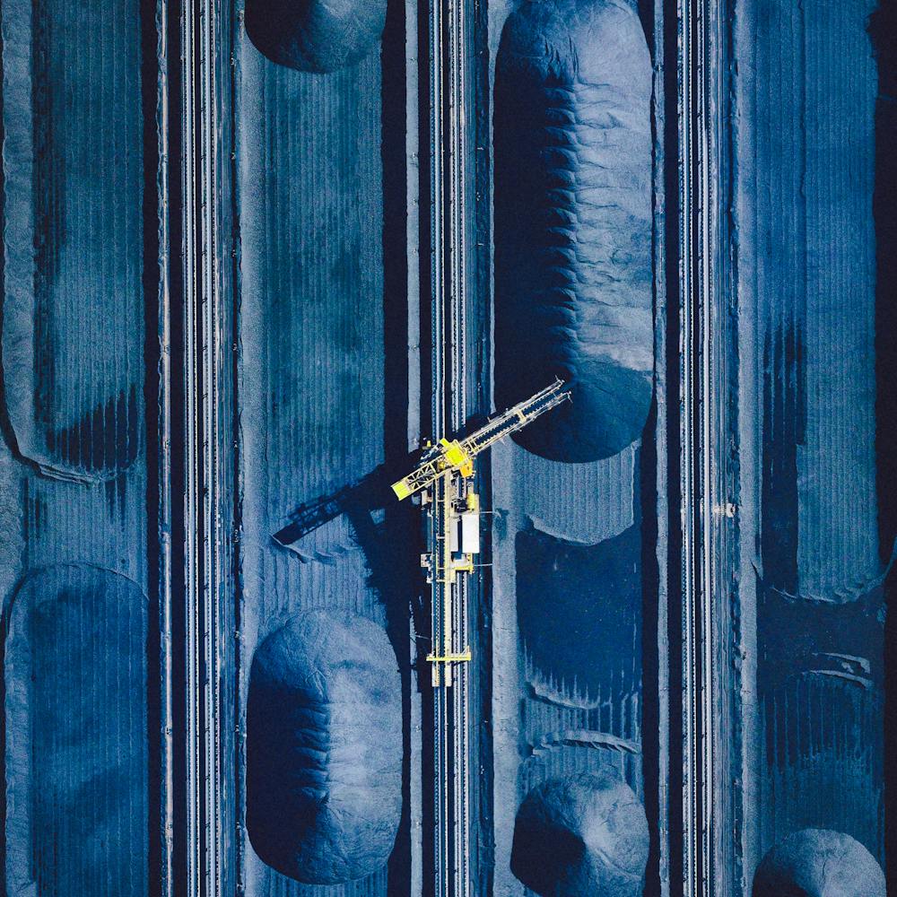
Kuata
-17.364778°, 177.135889° - Kuata, FijiKuata is one of about 20 islands that make up the Yasawa Group, an archipelago in the Western Division of Fiji. Although Kuata is less than one square mile in size, it is a popular tourist destination where visitors enjoy lounging on its beaches, swimming, and snorkeling among friendly white-tipped reef sharks.
Maxar Technologies
Kujalleq Frozen River
60.997556°, -45.010722° - GreenlandA frozen river is seen here in Kujalleq Municipality, Greenland. At 12,355 square miles (32,000 sq. km), Kujalleq is the smallest district in Greenland by area. Its coat of arms features a ram’s head, which symbolizes one of the area’s most important economic assets — sheep farming.
Maxar Technologies
Kuşadası
37.859722°, 27.259722° - Kuşadası, TurkeyKuşadası is a resort town located on the Aegean Sea in Turkey. While the town has roughly 64,00 residents for most of year, in the summer months its population can rise to nearly half a million people with the influx of tourists.
Maxar Technologies
Kuta
-8.733333°, 115.166667° - Kuta, Bali, IndonesiaKuta (also known as Kuta Village or Kuta Town) is a village in southern Bali, Indonesia. Originally a small fishing community, it was one of the first places in Bali to see substantial tourism and has become internationally known as a beach resort town. Kuta sits just north of Ngurah Rai International Airport, which is shown at the center of this Overview jutting out into the Indian Ocean.
Maxar Technologies
Kvíslavatn
64.558333°, -18.578750° - Kvíslavatn, IcelandKvíslavatn is a lake in the Highlands of Iceland, just southeast of the Hofsjökull glacier. It covers an area of roughly 7.75 square miles (20 sq. km) and reaches a depth of 36 feet (11 m). The Icelandic Highlands cover nearly all of the country’s interior and are mostly an uninhabitable volcanic desert.
Maxar Technologies
Kwinana Beach Tire Graveyard
-32.217833°, 115.774083° - Kwinana Beach, Australia, USAA forklift divides thousands of tires into uniform sections on a large lot in Kwinana Beach, Western Australia. Kwinana Beach is an industrial suburb of Perth that contains several large petro-chemical refineries, including those run by BP and Alcoa. In the 1970s, many residents of the suburb accepted property resumption offers from the local government citing increased pollution, health problems, and other nuisances caused by growing industrial development.
Nearmap
L'Eixample - Valenica
39.464722°, -0.370000° - Valencia, SpainThe urban plan of the L’Eixample district in Valencia, Spain is characterized by long straight streets, a strict grid pattern crossed by wide avenues, and apartments with communal courtyards. A similar layout was used for the district of the same name in Barcelona. The circular structure in the upper right is the Plaza de Toros de Valencia - the city’s largest bullfighting arena.
Maxar Technologies
L.F. Wade International Airport (BDA)
32.368277°, -64.685628° - BermudaL.F. Wade International Airport is the only airport in the British overseas territory of Bermuda. Due to the island's substantial distance from the nearest land mass, the airport only handles jets and long-range turboprops. The facility accommodates roughly one million passengers every year.
Maxar Technologies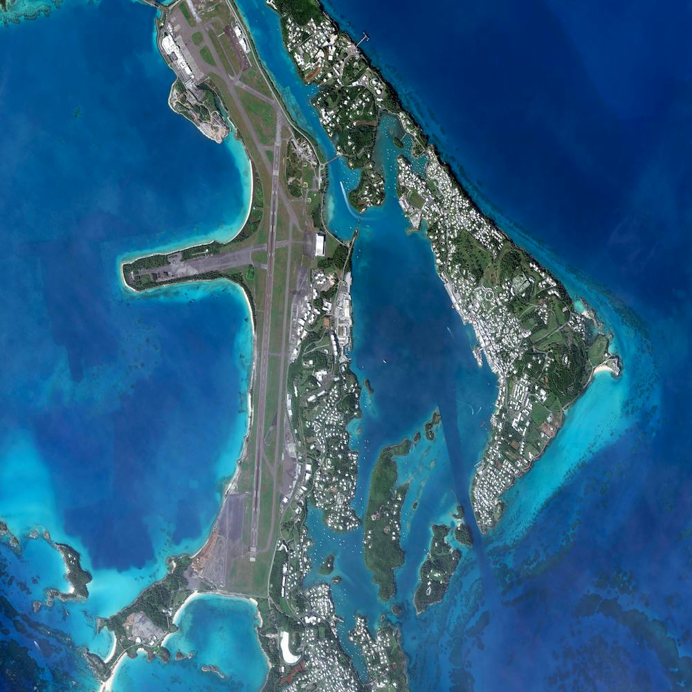
La Latina - Madrid
40.411500°, -3.710972° - Madrid, SpainLa Latina is a neighborhood located in the center of Madrid, Spain. The area was named after an old hospital of the same name that was founded in 1499. In the lower left of this Overview, you can also see the popular Mercado de la Cebada market, with its six-panel, multi-colored rooftop.
Maxar Technologies
La Payunia
-36.373331°, -69.550676° - La Payunia, ArgentinaReserva Provincial La Payunia, also known as Payún or Payén, is a nature preserve located in the southern part of Argentina's Mendoza Province. Spanning 1,737 square miles (4,500 sq. km), it is home to more than 70 animal species and a number of volcanic cones. Ash from these volcanoes forms a black terrain known as Pampas Negras, which can be seen spreading its way across this Overview.
Maxar Technologies
La Plata
-34.921111°, -57.954444° - -34.921111°, -57.954444°The planned city of La Plata — the capital city of the Province of Buenos Aires, Argentina — is characterized by its strict, square grid pattern. At the 1889 World’s Fair in Paris, the new city was awarded two gold medals in the categories “City of the Future” and “Better Performance Built.” La Plata has a population of around 765,000 people.
Maxar Technologies
Lacets de Montvernier
45.317611°, 6.337389° - Montvernier, FranceOn Thursday, cyclists racing in the Tour de France completed Stage 12 of the race, passing through the 18 hairpin turns of the Lacets de Montvernier in Montvernier, France. This spectacular climb is 2.1 miles long (3.4 km) and contains a switchback turn every 450 feet (150 m). Welsh cyclist Geraint Thomas, racing for Team Sky, won this stage in just under five hours and 20 minutes.
Maxar Technologies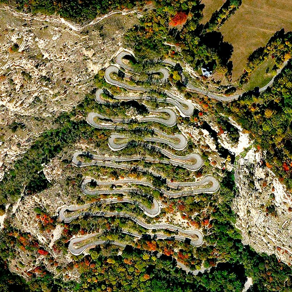
Lago Argentino
-50.216667°, -72.416667° - Patagonia, ArgentinaLago Argentino is the largest freshwater lake in Argentina, with a surface area of 546 square miles (1,415 square kilometers). Located in the Patagonia region on Argentina’s southern tip, it is fed by glacial meltwater from several nearby rivers. Due to its position within Los Glaciares National Park, the lake is also a popular tourism and fishing site.
Maxar Technologies
Lake Coipasa Salt
19.175639°, -68.036056° - Sabaya Province, BoliviaSalt deposits marble the shoreline of Lake Coipasa in Bolivia’s Sabaya Province. At an elevation of nearly 12,000 feet (3,657 m), the lake is fed by the Lauca River, which drops dark volcanic sediment along its northwestern shore. That sediment, shown on the right side of this Overview, contrasts sharply with the light blue water and white salt crust.
Maxar Technologies
Lake Cuowomo, China
29.794222°, 86.940833° - Tibet Autonomous Region, ChinaThe ultramarine waters of Lake Cuowomo add color to the landscape in Ngamring County, a remote section of the Tibet Autonomous Region in China. This lake, among others in Tibet, were favorite sites of NASA Astronaut Scott Kelly during his "Year in Space" mission in 2015-16.
Maxar Technologies
Lake Hood Seaplane Base
61.181667°, -149.966389° - Anchorage, Alaska, USAThe Lake Hood Seaplane Base, captured here during the frozen-over winter, is located in Anchorage, Alaska, USA. Handling an average of 190 flights per day, the facility is the world's busiest airport for seaplanes.
Maxar Technologies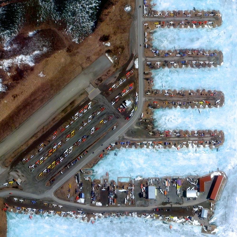
Lake Macleod
-24.117778°, 113.657500° - Carnarvon, AustraliaLake Macleod is the westernmost lake in Australia, located just north of the small coastal city of Carnarvon. Covering 500 square miles (1,500 sq. km), the lake is quite shallow with a maximum depth of about 5 feet (1.5 m). Large parts of the lake have been identified as Important Bird Areas, supporting fairy terns, red-necked stints, curlew sandpipers, banded stilts and other species.
Maxar Technologies
Lake Mead
36.221287°, -114.747849° - Lake Mead, USALake Mead — located on the Colorado River 24 miles (38 km) southeast of Las Vegas, Nevada — is the largest reservoir in the United States. The lake was formed with the creation of the Hoover Dam in the 1930s. Due to a combination of drought and increased water demand in the surrounding states (specifically California, Nevada, New Mexico, and Arizona) the lake’s water level has been lowering drastically in recent years. This decreasing water level exposes the white shoreline that is visible in this Overview.
Maxar Technologies
Lake Natron
-2.348486°, 35.731660° - Northern TanzaniaLake Natron is a salt lake in the Arusha Region of northern Tanzania, not far from the border with Kenya. It is shallow — less than 10 feet (3 m) deep — and varies in width depending on its water level. The color of Lake Natron is typical of saline lakes with high evaporation rates, in which salt-loving microorganisms thrive using photosynthesis to make their own food. A by-product of this photosynthesis causes deeper water to turn bright red and shallow parts of the lake to take on a rusty orange color.
Maxar Technologies
Lake Tandou
-32.595085°, 142.035856° - New South Wales, AustraliaThis Overview shows approximately 22 miles of Lake Tandou, an innovative water conservation project in New South Wales, Australia. The lakebed is protected from flooding and uses irrigation canals (the thin green lines) to grow cotton, sunflowers, and grains.
Maxar Technologies
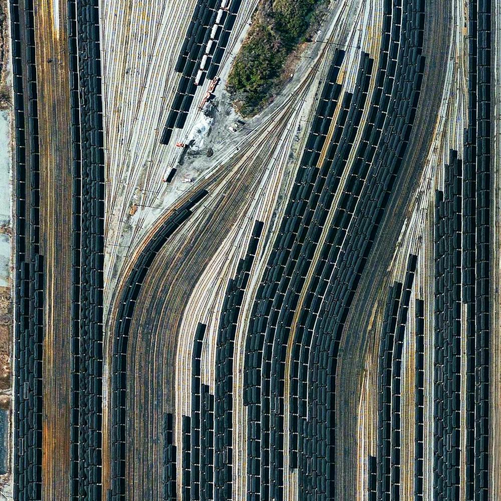
Lamberts Point Pier 6
36.875249°, -76.320260° - Norfolk, VirginiaTrain cars filled with coal are stationed in Norfolk, Virginia. Operated by the Norfolk Southern corporation, Lamberts Point Pier 6 is the largest coal-loading station in the Northern Hemisphere and serves at the temporary depot for the company’s fleet of 23,000 coal cars.
Nearmap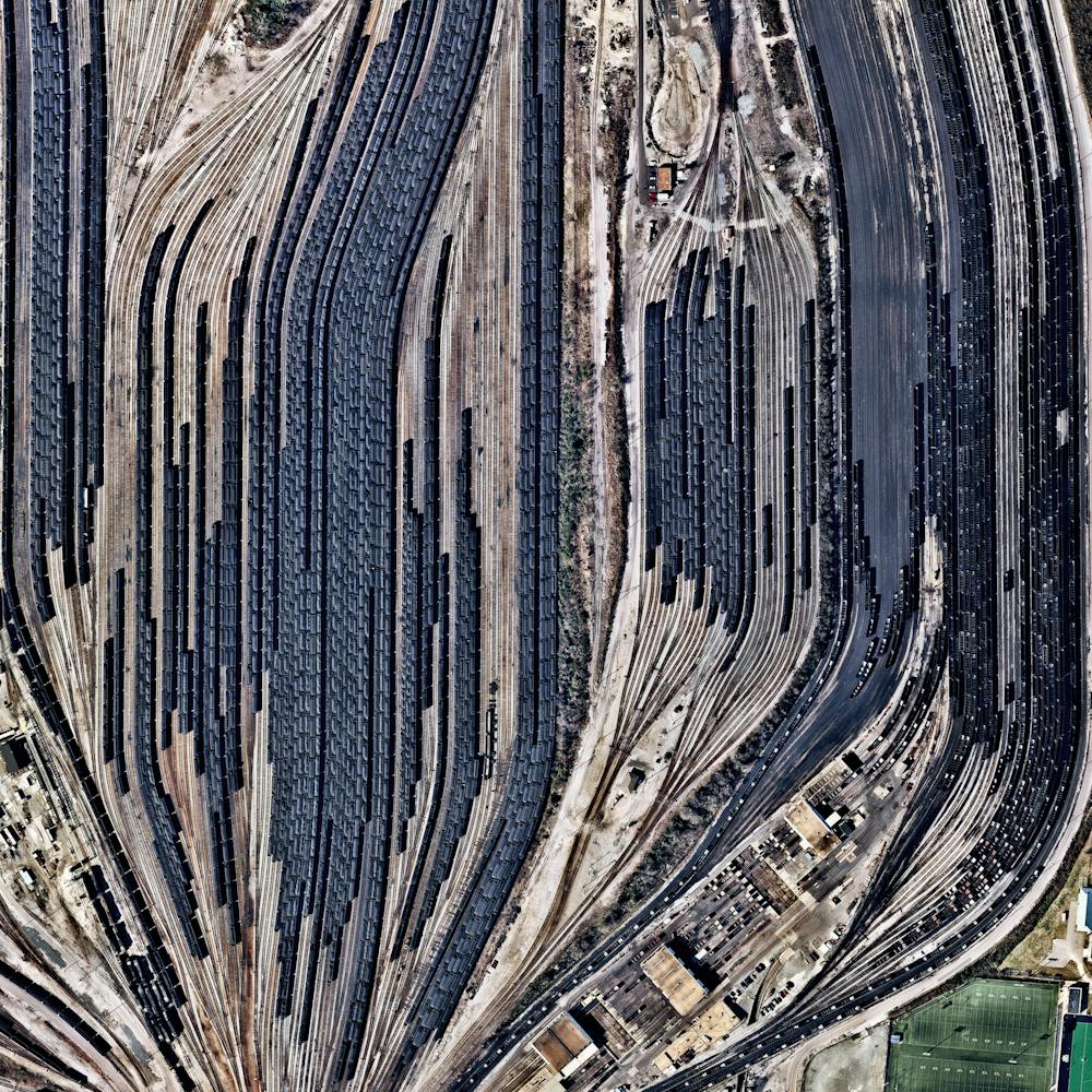
Lamberts Point Pier 6 Coal Railyard
36.875250°, -76.320250° - Norfolk, Virginia, USATrain cars filled with coal are stationed in Norfolk, Virginia. Operated by the Norfolk Southern corporation, Lamberts Point Pier 6 is the largest coal-loading station in the Northern Hemisphere and serves at the temporary depot for the company’s fleet of 23,000 coal cars.
Nearmap