 Explore
 Shop
Shop About
About Search
Daily
One regular dose of Earth from above

“Super Pit” Tailings Pond
-30.797726°,121.563870° - Nearmap
A rectangular tailings pond changes appearance as waste is pumped in from the nearby Fimiston Open Pit gold mine in Kalgoorlie, Western Australia. Covering about 0.82 square miles (2.1 sq km), this pond is five times the size of the Vatican City and holds millions of tons of tailings — rocks and chemicals left over after gold is extracted. Fimiston, also called “Super Pit,” is the sixth-deepest open-pit mine in the world, at 1,968 feet (600 m).


Chiang Mai
18.795278°,98.998611° - Maxar
Chiang Mai is the largest city in northern Thailand with nearly one million residents. The Old City, seen here, was founded in 1296 and still retains much of its square-shaped moat and defensive walls. Chang Mai is home to more than 100 elaborate Buddhist temples, including 14th-century Wat Phra Singh and 15th-century Wat Chedi Luang, which attract tourists from all around the world.

Kooragang Island Coal
-32.875306°,151.767778° - Nearmap
Large piles of coal await shipment on Kooragang Island, part of the Port of Newcastle in New South Wales, Australia. The island is one of the world's largest coal export facilities, with a capacity of at least 120 million tonnes per annum. In 2022, coal trading comprised more than 97% of revenue at the Port of Newcastle; however, the port plans to reduce this figure to 50% by 2030 and fully decarbonize by 2040.

Science World
49.273251°,-123.103767° - Nearmap
Science World is a science-themed museum in Vancouver, British Columbia, Canada. Originally constructed for the 1986 World’s Fair, the structure features a 180-foot-tall (55-meter) geodesic dome wrapped in metal scaffolding and nearly 400 lights. It is located at the end of False Creek, a narrow inlet that separates Downtown Vancouver from the rest of the city.

Bakhmut
48.594722°,38.000833° - Tyler Hicks / The New York Times
Bakhmut, Ukraine, once a city of nearly 80,000, has been obliterated by a year of shelling and assault from the Russian Armed Forces. An estimated 4,000 people were left in the city as of March, almost every building has been left scorched or reduced to rubble, and craters can be seen in parks and courtyards. Last week, Russia claimed to have captured Bakhmut, while a small outfit of Ukrainian forces remains on the eastern side of the city.
Diavik Diamond Mine
64.496111°,-110.273333° - Maxar
The Diavik Diamond Mine is located on Lac de Gras lake in the Northwest Territories of Canada, 120 miles (193 km) south of the Arctic Circle. The mine produces approximately 7.5 million carats of diamonds each year. In standard weight, that’s an annual output of 3,300 pounds (1,500 kg). In this Overview, the most distinguishable areas of the facility are its two primary open pits, waste ponds, processing facilities, and an airstrip capable of landing aircraft as large as 737s and C-130s.

Osaka
34.693574°,135.458128° - Maxar
Stretching along Osaka Bay and crisscrossed by rivers and canals, Osaka is known as Japan’s “city of water.” The Yodo River, seen here at center, is spanned by several bridges that connect the city’s numerous wards and districts. With a population of 2.7 million, Osaka is the third most populous city in Japan.

Yukon River
66.257263°,-147.813035° - Maxar
The Yukon River is the third-longest river in North America, flowing 1,980 miles (3,190 km) through northwestern Canada and the U.S. state of Alaska before emptying into the Bering Sea. At 321,500 square miles (832,682 sq km), its total drainage area is about 10 times the size of Ireland. This Overview shows a section of meanders near the community of Beaver, Alaska — population 48.

Lehua Island
22.019943°,-160.096460° - Maxar
Lehua is a small, crescent-shaped island located about 20 miles (32 km) west of the Hawaiian Island of Kauai. Formed by the cone of the extinct Ni’ihau volcano, the island spans 279 acres (1.13 square km). Lehua is an uninhabited wildlife sanctuary, providing habitats for at least 17 seabird species and 25 native plants along its steep, rocky shores.
Pembrokeshire
52.014500°,-5.087222° - Maxar
Pembrokeshire is a county in the south west of Wales. The county is home to Pembrokeshire Coast National Park, the only coastal national park of its kind in the United Kingdom, which includes a 186-mile walking trail, the Pembrokeshire Coast Path. In the north of the county are the Preseli Hills, a wide stretch of high moorland with many prehistoric sites and the probable source of the bluestones that were used in the construction of the inner circle of Stonehenge in England.
Portland, Oregon
45.520000°,-122.681944° - Nearmap
This Overview shows downtown Portland, Oregon, on the banks of the Willamette River. With more than 650,000 inhabitants, it is Oregon’s largest and most-populous city and the second-most populous in the Pacific Northwest. Portland’s cityscape is defined by its numerous bridges, many of which are historic and the three most traveled — Hawthorne Bridge, Steel Bridge and Broadway Bridge — are more than 100 years old.

Lake Tai
31.209180°,120.101525° - Google Timelapse
In eastern China, Lake Tai (Tai Hu) has become almost surrounded by urban development in recent decades. Three cities — Huzhou, Suzhou, and Wuxi — have grown dramatically since 1985, their collective populations increasing from 1.7 million to more than 12.5 million. In 2007, the Chinese government pledged more than $14 billion to clean up Lake Tai, which had been contaminated for years by improper disposal of chemicals and sewage.

Tibetan Lakes
35.248659°,90.014363° - Google Timelapse
The Tibetan Plateau contains hundreds of lakes, many of which play an essential role in supplying water to Asia’s large river systems. Some, however, are not connected to a river system but have nevertheless experienced significant water volume changes in recent decades. Research points to climate-induced changes in the permafrost thaw cycle, which has increased water supply to existing lakes and created new bodies of water.
Powderhorn Park
44.942944°,-93.256916° - Nearmap
Powderhorn Park is a residential neighborhood of Minneapolis, Minnesota, consisting mostly of single-family homes, duplexes and some low-rise apartment buildings. The community's eponymous park system and lake — shown at the center of this Overview — hosts local sporting events, community education classes, and ice skating in the winter.

Calgary Low-Angle
51.045119°,-114.071139° - Nearmap
Check out this Overview of Downtown Calgary captured at a low angle. With more than 1.3 million inhabitants, Calgary is the third-largest city in Canada and largest in the province of Alberta. Several city landmarks are visible from this perspective, including Calgary Tower, Prince’s Island Park, and The Bow — a crescent-shaped skyscraper.

Haneda Airport
35.553333°,139.781111° - Maxar
Haneda Airport is one of two international airports serving Greater Tokyo, Japan. Officially known as Tokyo International Airport, it opened in 1931 and has gradually expanded on reclaimed land to encompass three passenger terminals and four runways. Haneda handled upwards of 87 million passengers in 2018, making it the third-busiest airport in Asia and the fourth-busiest in the world.

Fraser River Log Booms
49.212508°,-123.192037° - Nearmap
Log booms, each containing hundreds of logs tied together, are transported along the Fraser River near Vancouver, British Columbia, Canada. The river provides a direct route to sawmills and pulp-and-paper mills along its banks, and also serves as temporary freshwater storage before shipping overseas. In 2021, approximately 8.9 billion Canadian dollars worth of lumber was exported from British Columbia to the rest of the world.
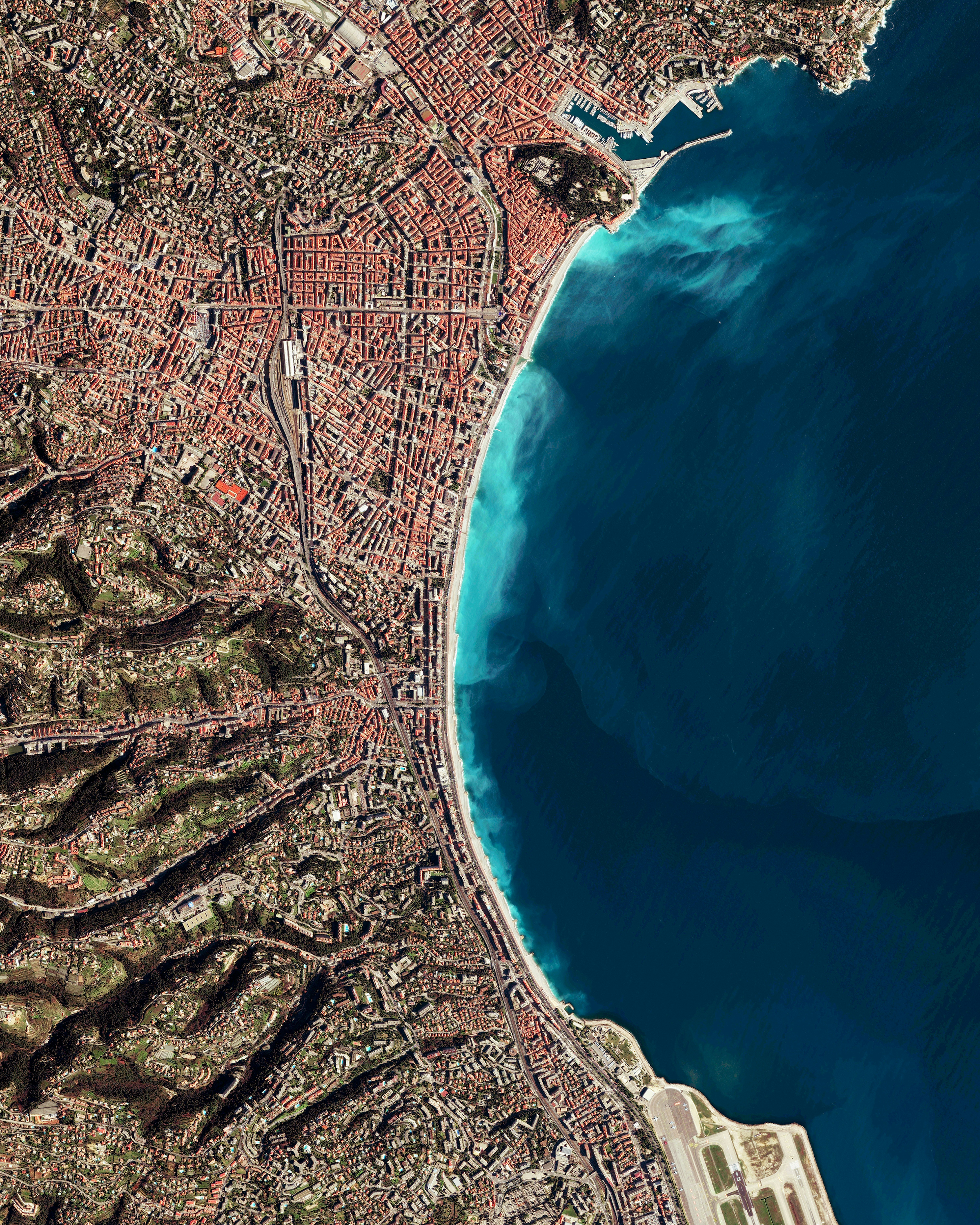
Nice
43.703389°,7.266306° - Maxar
Nice is the fifth most populated city in France, with roughly one million inhabitants in its metropolitan area. Located in southeastern France on the Mediterranean Sea, Nice is part of the tourist-popular French Riviera. It has one of the highest hotel capacities in France and during a regular year is visited by more than four million tourists.

Churchill Downs
38.203056°,-85.770000° - Nearmap
The 149th running of the Kentucky Derby takes place today at Churchill Downs in Louisville, Kentucky, USA. Called “The Most Exciting Two Minutes in Sports,” the 1.25-mile (2-km) race is the first leg of the American Triple Crown series, followed by the Preakness Stakes and then the Belmont Stakes. Roughly 150,000 people will be in attendance for the race, and millions more will watch at home.

Willie Creek
-17.762556°,122.237278° - Maxar
Willie Creek is a protected tidal estuary roughly 10.5 miles (17 km) north of Broome, Western Australia. The creek’s calm, nutrient-rich waters make it an ideal habitat for the Pinctada maxima oyster, which produces world-renowned pearls.