 Explore
 Shop
Shop About
About Search
Daily
One regular dose of Earth from above

Mars Backshell Wreckage
0.000000°,0.000000° - NASA
This Overview of Mars, captured by NASA’s Ingenuity helicopter, shows the wreckage of a “backshell” — a component that detached from the Perseverance rover when it landed on Mars in February 2021. We can also see the backshell’s 70-foot-wide (21-meter) parachute in frame. The Ingenuity is a robotic helicopter that follows the Perseverance rover around Mars, taking photos as it hovers above the red planet’s surface. This photo was taken, along with 9 others, during its 26th flight last week, which lasted 159 seconds and spanned 1,181 feet (360 meters).


Santorini
36.416667°,25.433333° - Maxar
Santorini, officially known as Thira, is a Greek island in the southern Aegean Sea. It is known for its beautiful scenery and traditional architecture — low-lying cubical houses made of stone, often whitewashed to reflect the hot mediterranean sun. Santorini’s primary industry is tourism, welcoming about 2 million visitors every year. This Overview also shows Therasia, Nea Kameni, Palaia Kameni, and Aspronisi, four smaller islands included in the municipality of Santorini.

Kuala Lumpur
3.147778°,101.695278° - Maxar
Kuala Lumpur is the capital and largest city in Malaysia, with an estimated 1.73 million residents. In recent decades, the city center has undergone rapid development and seen the addition of numerous skyscrapers, including the Petronas Towers — the tallest twin buildings in the world. In fact, Kuala Lumpur ranks 10th among cities with buildings above 100 meters, with a combined height of 34,035 metres from its 244 high rise buildings.

Iceland
64.963100°,-19.020800° - Airbus Space
Iceland is a Nordic island nation famous for its dramatic landscape of volcanoes, geysers, lava fields, fjords and hot springs. It also contains some of Europe’s largest glaciers, including Vatnajökull, a massive ice cap that covers about 8% of the country’s land area. Iceland has roughly 371,000 residents, more than 65% of whom live in the capital city of Reykjavík.
Plaza Mayor
40.415364°,-3.707398° - Costas Spathis
Plaza Mayor is a public square in the heart of Madrid, Spain. Dating back to the 15th century, it once served as the central marketplace of Old Madrid. Today, the 130,000-square-foot (12,000-square-meter) space still provides residents and tourists a location for shopping, eating, and enjoying a space outdoors.
Mount Vesuvius
40.822382°,14.420151° - Maxar
Mount Vesuvius is a somma-stratovolcano located in Campania, Italy, about 5.6 miles (9 km) east of Naples. It is best known for its eruption in AD 79, which killed thousands and destroyed the Roman cities of Pompeii, Herculaneum, Oplontis and Stabiae. With an eruption as recent as 1944 and at least 3 million living nearby, Vesuvius is regarded as one of the most dangerous volcanoes in the world.

Wallis
-13.287898°,-176.200937° - Planet
Wallis, also known as Uvéa, is a Polynesian atoll in the Pacific Ocean belonging to the French overseas collectivity of Wallis and Futuna. Surrounded by a lagoon, barrier reef and some 15 smaller islands, it spans 39 square miles (100 square km) and has 8,333 residents. Wallis is of volcanic origin, with fertile soil and plentiful rainfall to support subsistence farming.

La Condesa
19.412525°,-99.169422° - Maxar
La Condesa is a neighborhood in the Cuauhtémoc Borough of Mexico City, located a few miles west of the city's main square. Its wide, tree-lined avenues, stately art nouveau mansions and well-maintained art deco apartment buildings give it a distinctly European feel. Avenida Amsterdam, the elliptical roadway seen on the left side of this Overview, was used as a private automobile and horse-racing track in the early 1900s; today it encircles Parque México, a large urban park.

The Vatican
41.902500°,12.452500° - Airbus Space
Happy Easter! This Overview shows the Vatican City and the surrounding city of Rome, Italy from a low angle. At the top we see St. Peter’s Basilica, regarded as one of the holiest Catholic sites and one of the greatest architectural feats in all of Christendom. With an area of 121 acres (49 hectares) and a population of about 825, The Vatican is the smallest state in the world by both area and population.
Gruissan
43.107778°,3.084444° - Maxar
Gruissan is a commune of about 5,000 residents, located on the Mediterranean coast of southern France. Traditionally a fishing village, the circular town is built around a former 10th century château, of which only the Tour Barberousse (Redbeard Tower) remains. The castle ruin can be seen near the center of this Overview surrounded by green trees.

Penikese Island
41.450107°,-70.923091° - Maxar
Today, Lindblad Expeditions introduces Penikese Island, part of the Elizabeth Island chain in Buzzard’s Bay, Cape Cod, Massachusetts. Since the late 19th century, the island has contained a natural history school, a leprosy hospital for residents of Massachusetts, and a substance abuse treatment facility. All are gone now with only resident seabirds remaining, along with a few wind-worn, shingled rustic buildings in the classic, archetypal style of the Cape, set on a grassy plain overlooking the bay. To learn more or explore this region, visit expeditions.com.
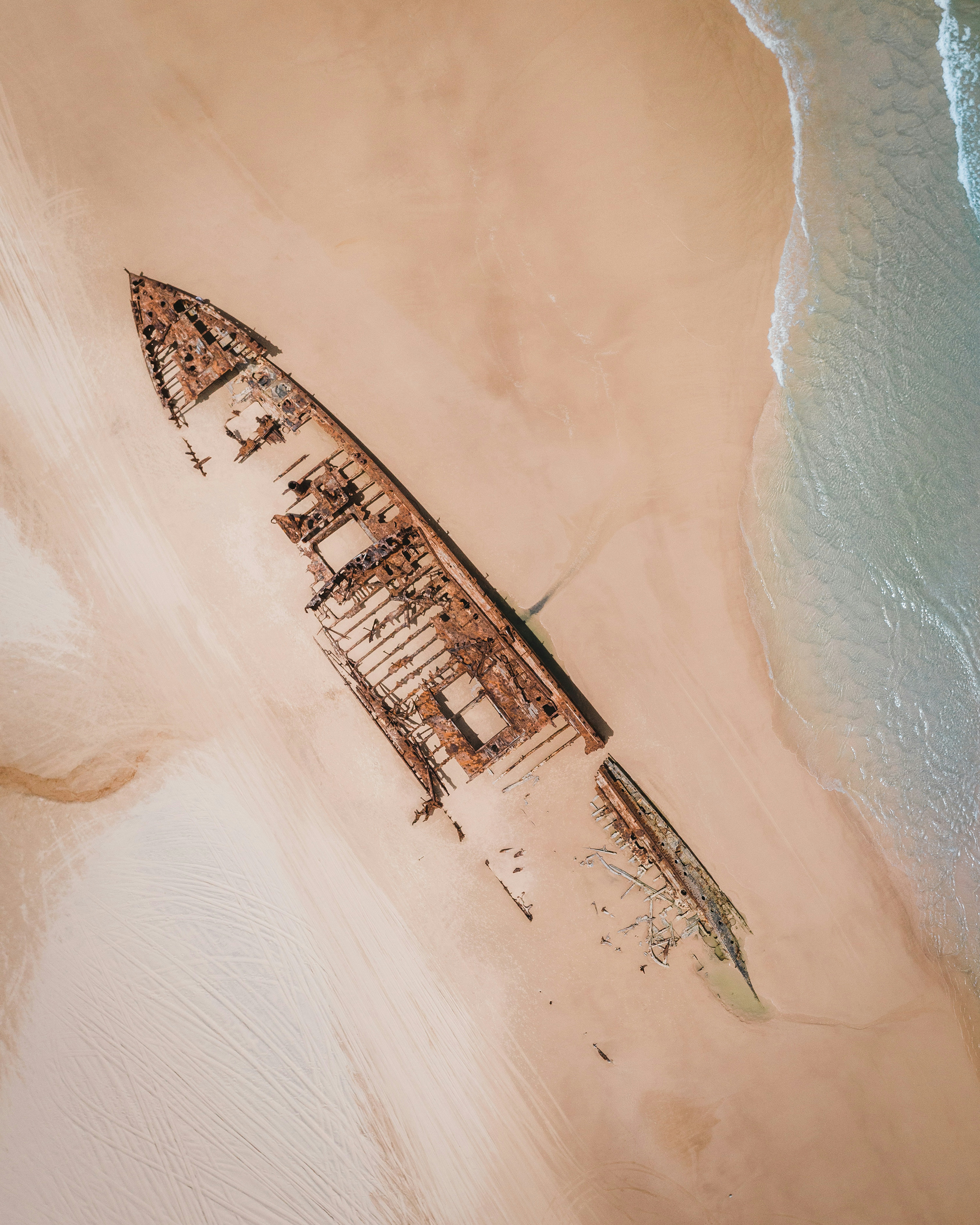
SS Maheno Shipwreck
-25.267349°,153.238534° - Andreas Dress
The wreck of the SS Maheno can be found on the east coast of Fraser Island in Queensland, Australia. The ship — which was washed ashore by a cyclone in 1935 — was an ocean liner that made regular crossings between New Zealand and Australia in the early 20th century. The 5,000-ton steel-hulled ship has slowly disintegrated over the years and remains a popular tourist attraction.

Lake Suğla
37.310056°,32.028551° - Planet
Agricultural development surrounds Lake Suğla in southwestern Turkey. Water levels in the lake fluctuate greatly throughout the year, causing its surface area to range between 9 and 31 square miles (25-80 square kilometers). The lake’s cloudy green color in this Overview is likely due to a high concentration of algae.

Hawaii
21.307500°,-157.857500° - Airbus Space
Hawaii is an archipelago located about 2,000 miles (3,200 km) from the U.S. mainland in the Pacific Ocean. The state is comprised of 137 volcanic islands, several atolls, and numerous small seamounts. A common explanation of the name Hawaii (also the name of its largest island) is that it was named for Hawaiʻiloa, a legendary figure from Hawaiian myth. Upwards of 1.4 million people currently live here.
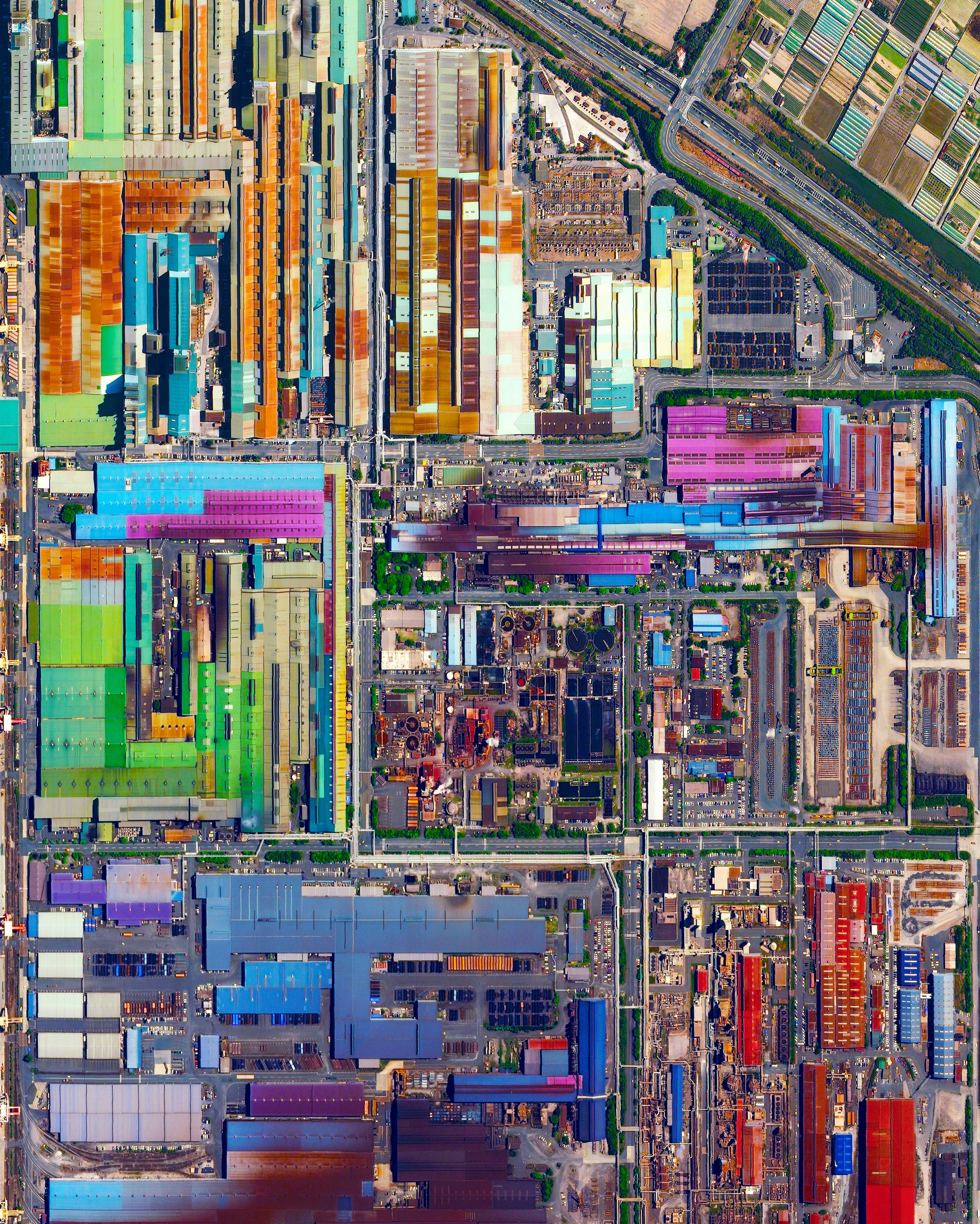
Tokai Steel Mill
35.035200°,136.878900° - Maxar
Colorful, metal-roofed industrial buildings line the coast of Tokai, Japan. The city’s economy is dominated by a massive steel mill, a portion of which is seen at the bottom of this Overview. Nippon Steel, the company that owns the mill, has an annual production of more than 47 million tons of steel across its various facilities. Steel—consisting of alloys of iron and other elements, primarily carbon—is a major component in buildings, infrastructure, tools, ships, automobiles, appliances, and weapons.

Augusta National Golf Club
33.500996°,-82.022189° - Nearmap
The Masters Tournament, played at Augusta National Golf Club in Augusta, Georgia, enters its second of four rounds today. It is the first of four major championships in professional golf, followed each year by the PGA Championship, U.S Open and The Open Championship. South Korean Sung-jae Im finished Round 1 in the lead, but much attention is on five-time Masters winner Tiger Woods, who returns after a year of recovery following a 2021 car accident. Who are you rooting for?

Bahamas Clouds
23.919435°,-79.882190° - Maxar
Clouds cover the Atlantic Ocean in the waters off the coast of The Bahamas. Cumulus clouds like these usually occur on sunny days, usually no higher than 6,600 feet (2,000 m) above the ground. Normally, cumulus clouds produce little or no rain, but they can grow into precipitation-bearing cumulonimbus clouds.

Central Park Foliage
40.782222°,-73.965278° - Craig Fruchtman
Check out this shot of Central Park with fall foliage ! Located in the middle of Manhattan in New York City, the park spans 843 acres — or 6% of the borough. One of the most influential innovations in the park's design was its "separate circulation" systems for pedestrians, horseback riders, and automobiles. This concealed "crosstown" commercial traffic in sunken roadways, and densely planted shrub belts in order to maintain a rustic ambiance.

Puente de Vallecas
40.380130°,-3.655530° - Maxar
Colorful apartment buildings with communal courtyards are seen here in the Puente de Vallecas district of Madrid, Spain. The district has around 240,000 mostly working-class inhabitants.

Everglades National Park
25.364334°,-81.121068° - Maxar
Everglades National Park in Florida is the largest tropical wilderness in the United States east of the Mississippi River, covering more than 1.5 million acres. The park was established in 1934 to protect the area’s fragile ecosystem and is home to dozens of threatened or protected species, including the American crocodile and West Indian manatee.