 Explore
 Shop
Shop About
About Search
Daily
One regular dose of Earth from above
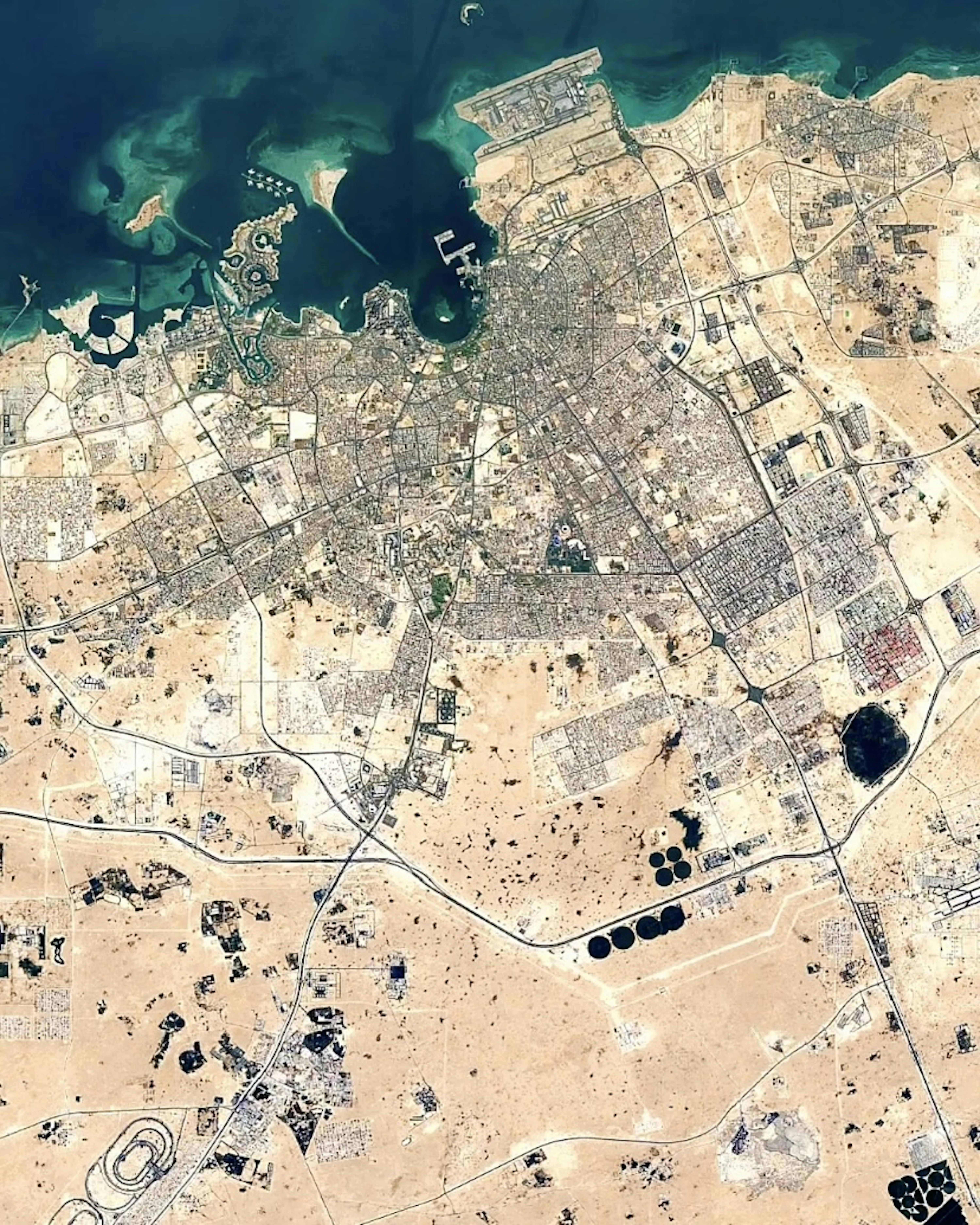
Doha
25.286667°,51.533333° - NASA / Google Timelapse
Doha became the capital city of Qatar in 1971, and shortly thereafter, began growing at rapid speed. The city's population exploded from 90,000 in the 1970’s to more than 2.3 million today. Doha’s cityscape has also expanded drastically, sprawling outward into the desert and the Persian Gulf atop reclaimed land.


Osaka and Kobe
34.500000°,135.300000° - NASA / Google Timelapse
Osaka and Kobe, Japan expand into Osaka Bay as land reclamation projects are completed over recent decades. Approximately 0.5% of Japan’s total area is estimated to be reclaimed land, which has been created for facilities like the 10.5 square kilometer (4 square mile) Kansai Airport that appears at left. Osaka is the 10th largest urban area in the world with more than 19 million inhabitants.
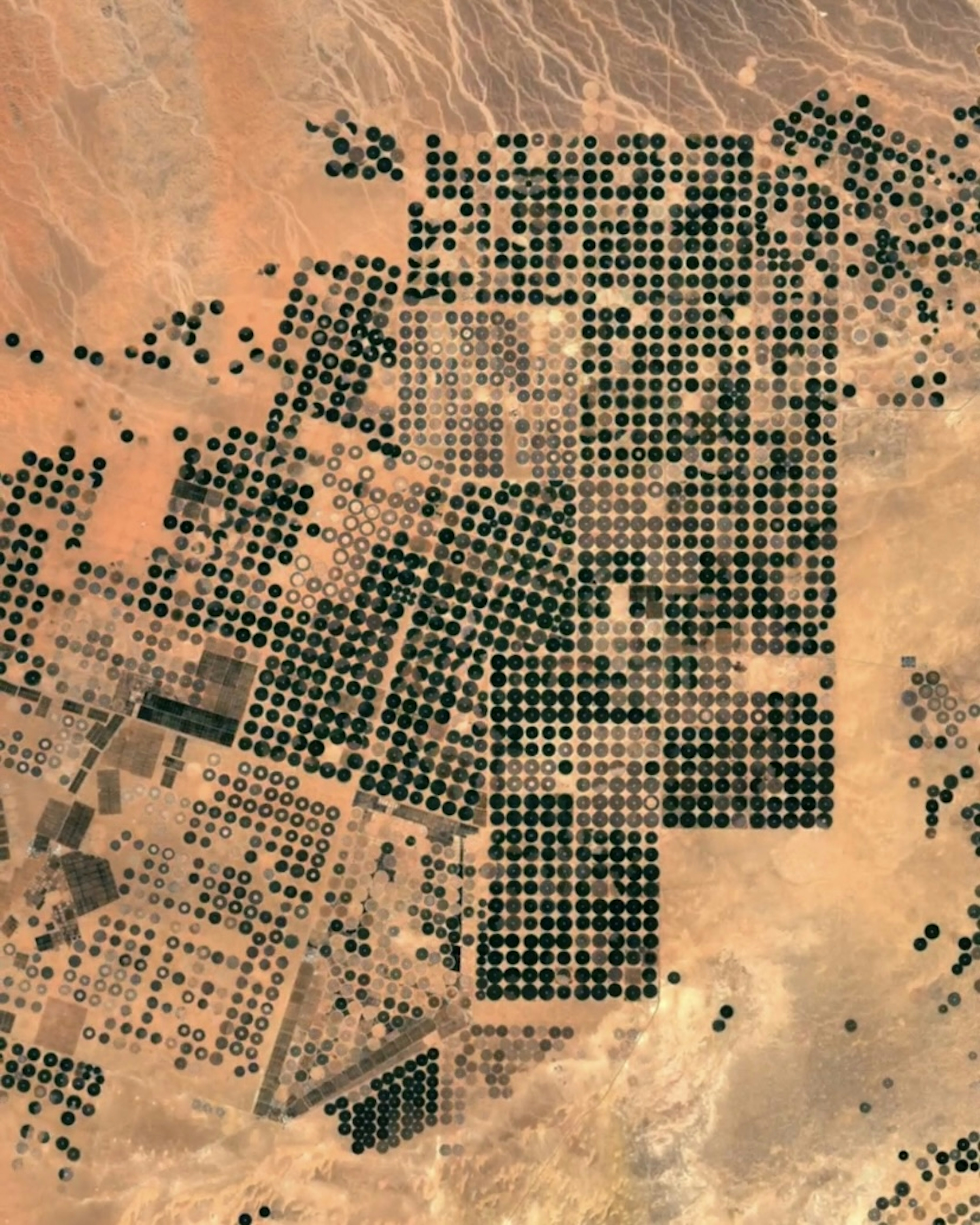
Saudi Arabia Irrigation
30.019630°,38.437350° - NASA / Google Timelapse
Saudi Arabia has worked for nearly 30 years to irrigate the Syrian Desert, where it grows wheat and other crops. To do so, it has drilled through the desert floor and drawn water from underground aquifers, which irrigates fields through center-pivot irrigation — creating the green circles seen here. This operation, in the Wadi As-Sirhan Basin, covers roughly 7,800 square kilometers (3,000 square miles) and each circular field is about one kilometer (0.62 miles) across.
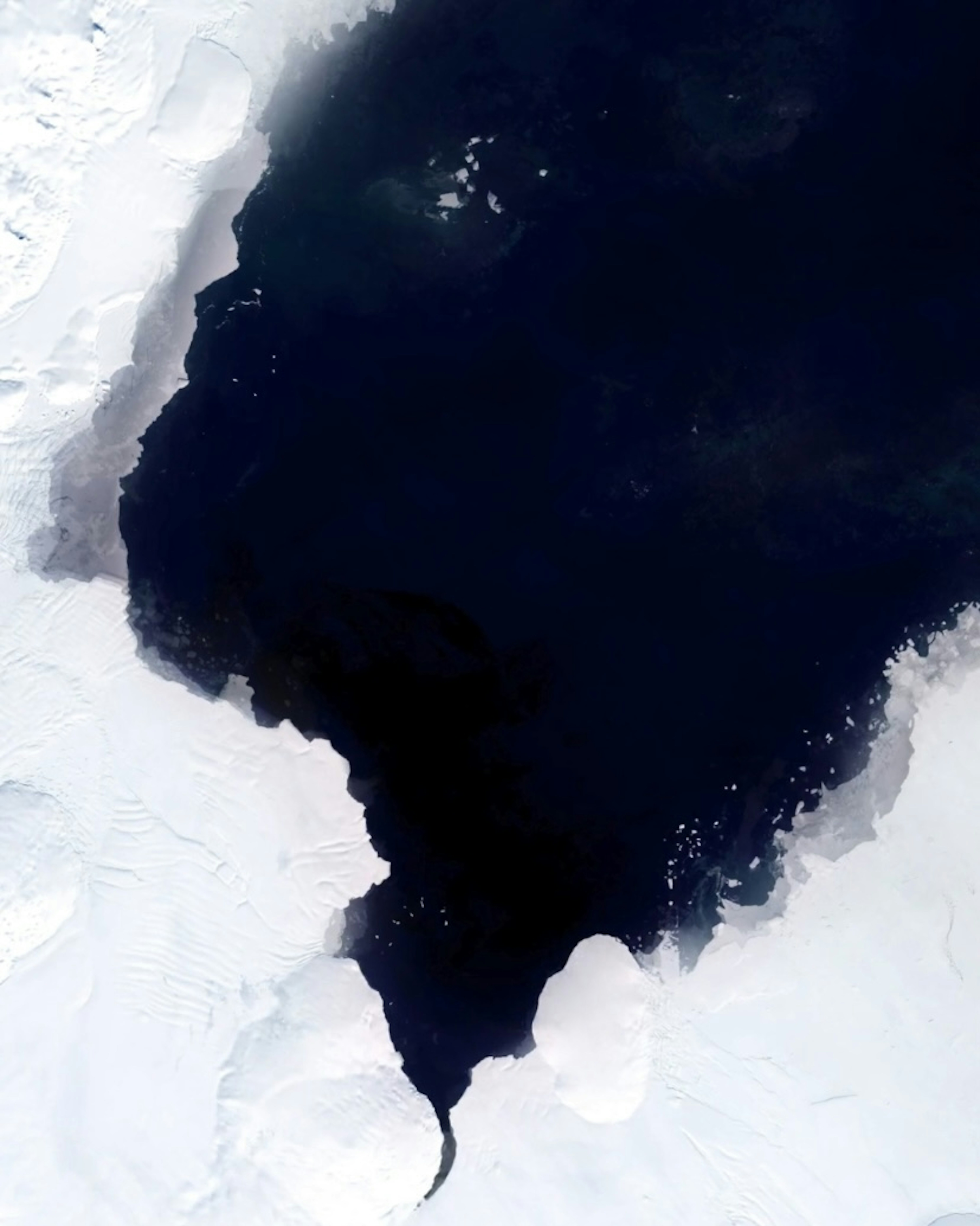
Antarctic Sea Ice Timelapse
-76.865660°,-153.302680° - NASA / Google Timelapse
Antarctic sea ice has gradually diminished over the last few decades, as surrounding oceans have grown warmer and northward winds stronger. Visit our Instagram @dailyoverview to watch a Timelapse video of melting in a ~18,000 square kilometer (7,800 square mile) area near the Ross Sea. In the last decade, Antarctica lost an estimated 252 billion tons (229 billion metric tons) of ice per year.

Cancún, Mexico
21.160556°,-86.847500° - NASA / Google Timelapse
Cancún, Mexico, has grown significantly in the last few decades, quickly becoming one of the most popular tourist destinations on the Caribbean Sea. The resort city was developed on the site of a coconut plantation with three residents in the 1970s and by 2019 was able to accommodate more than 6 million tourists. Its population and urban footprint has also boomed; in the mid-1980s the Cancún metro area was home to about 70,000 people, and today it has nearly 1 million inhabitants. Visit our Instagram @dailyoverview to see a Timelapse video of Cancún growing.

Google Bay View Campus
37.421849°,-122.066877° - Nearmap
Construction of Google’s Bay View campus in Mountain View, California began in 2017 and the facility just opened to employees in May 2022. The all-electric structure is net water positive, powered by a dragonscale solar-skin exterior, and boasts the largest geothermal installation in North America. Located on 42-acres, Bay View can accommodate 4,000 employees.

Australia Bushfires
-29.833700°,123.928930° - NASA / Google Timelapse
Australian bushfires are a regular occurrence that have shaped the landscape of the continent over millions of years. However, because the most destructive fires are usually preceded by higher temperatures, global warming has increased — and is predicted to continue increasing — the frequency of blazes. Visit our Instagram @dailyoverview to see a Timelapse of ~3200 square miles of Western Australian with scorched areas gradually growing over the last few decades.

Mariupol Timelapse
47.095833°,37.549444° - Maxar
Mariupol, Ukraine was destroyed between February and May 2022 during the Russian invasion of the country. Some estimates say at least 95% of the city, now under Russian control, has been leveled. Visit our Instagram @dailyoverview to watch a Timelapse video of the city, which focuses on the Mauripol Theater destroyed by Russian bombardments on March 16. Tens of thousands of civilians have been evacuated or killed, leaving Mariupol with less than 100,000 of its 430,000 residents.

Kuala Lumpur Growth
3.147778°,101.695278° - NASA / Google Timelapse
Kuala Lumpur, Malaysia has grown sixfold since the 1980s, it’s population exploding from 1.3 million in 1984 to more than 8 million today. As a result, the metropolis continues to sprawl outward from the Klang River and now covers more than 1,000 square miles (2,800 square km). Visit our Instagram @dailyoverview to see a Timelapse of the city’s growth.

Apple Park
37.334185°,-122.009930° - Nearmap
Apple Park in Cupertino, California is the 2.8 million-square-foot headquarters of Apple. Construction of the building took roughly four years to complete, from 2013 to 2017. The “Spaceship” is one of the world’s most environmentally friendly offices, with 100% of its power coming from renewable sources, including the the world’s largest rooftop solar installation. Visit our Instagram @dailyoverview to watch a Timelapse of Apple Park being built.

Las Vegas and Lake Mead
36.175000°,-115.136389° - NASA / Google Timelapse
As the city of Las Vegas grows, Lake Mead, its water supply, shrinks. In the mid-1980s, the Vegas metropolitan area was home to 438,000 people, and today that population has ballooned to upwards of 2.2 million. Consequently, the lake’s water level has dropped from 1,225 feet in July 1983 to 1,059 feet in May 2022 — the lowest since it first began to fill in 1935. Visit our Instagram @dailyoverview to see a video of the city growing and lake shrinking.

Santa Cruz Deforestation
-17.546054°,-62.105244° - NASA / Google Timelapse
Here’s 2000 square kilometers (800 sq. miles) of deforestation in the Santa Cruz region of Bolivia. Deforestation in the country has primarily been driven by the expansion of mechanized agriculture, as Bolivia seeks to produce more food for its growing population. From 2002 to 2021, the country lost a total of 66,000 square kilometers (25,400 square miles) of tree cover — that’s an area 40 times the size of London. Visit our Instagram @dailyoverview to watch a Timelapse of the deforestation.

European Air Traffic
54.526000°,15.255100° - Plane Finder
Flight traffic across Europe has drastically increased from two years ago when COVID-19 lockdowns were in place. The number of people travelling by air across Europe plummeted from 1.1 billion in 2019 to 277 million in 2020. Now, air traffic has begun to rebound — commercial flights in March 2022 were up 156% from March 2021, but are still about down 20% from pre-pandemic levels. Visit our Instagram @dailyoverview to see a comparison of April 2020 and March 2022.

Aral Sea Timelapse
45.510578°,58.757118° - NASA / Google Timelapse
The Aral Sea, located on the border of Kazakhstan and Uzbekistan, was once the fourth largest lake in the world. Visit our Instagram @dailyoverview to watch a Timelapse of its water levels gradually decreasing. In the 1960s, the rivers that fed the Aral were diverted to irrigate newly created cotton fields in the adjacent Kyzylkum Desert. By 1997, water volume had declined to 10% of its original size, and recent satellite images show its entire eastern basin dried up.

Shanghai
31.230400°,121.473700° - NASA
Shanghai, China is an enormous city, but it hasn’t always been that way. In recent decades, the city’s population and urban footprint have exploded. You can watch a Timelapse video of the city growing on Instagram (@dailyoverview). When the Timelapse begins, in 1982, the population was about 11.8 million, and now it is roughly 24.4 million. Earlier this week, residents of the enormous city emerged from their homes after a two-month COVID-19 lockdown. However, negative tests are still required for people to enter many public places throughout Shanghai.

Arlington National Cemetery
38.878325°,-77.068671° - Maxar
In honor of Memorial Day in the United States, we’ve selected an Overview of Arlington National Cemetery outside of Washington, D.C. Since the American Civil War, the 624-acre cemetery has become the final resting place for veterans of the nation’s conflicts. The structure seen here is the Arlington Memorial Amphitheater that also contains the Tomb of the Unknown Soldier.

Vulkathunha-Gammon Ranges National Park
-30.626250°,139.055882° - Planet
Vulkathunha-Gammon Ranges National Park is a protected area in South Australia, nearly 300 miles (482 km) north of Adelaide. It contains some of the most rugged and spectacular landscape in the state, with high plateaus, gorges and deep chasms. The park is inhabited by the Adnyamathanha aboriginal people.

Victoria Falls
-17.924444°,25.856667° - Airbus Space
Victoria Falls is a waterfall located on the Zambezi River at the border of Zambia and Zimbabwe. While it is neither the highest nor the widest waterfall in the world, it is classified as the largest with a width of 1,708 meters (5,604 ft) and height of 108 meters (354 ft). Accordingly, the falls contains the world’s largest sheet of falling water with a flow of about 1,080 cubic meters per second.

Brickpit Ring Walk
-33.841667°,151.071389° - Nearmap
The Brickpit Ring Walk is an urban nature park and walkway in Sydney Olympic Park, New South Wales, Australia. The 1,804-foot (550-m) elevated walkway is built above a former brick quarry, now water storage facility and habitat for the endangered Green and Golden Bell Frog. In this Overview, bright green algae swirls on the surface of the storage pond.
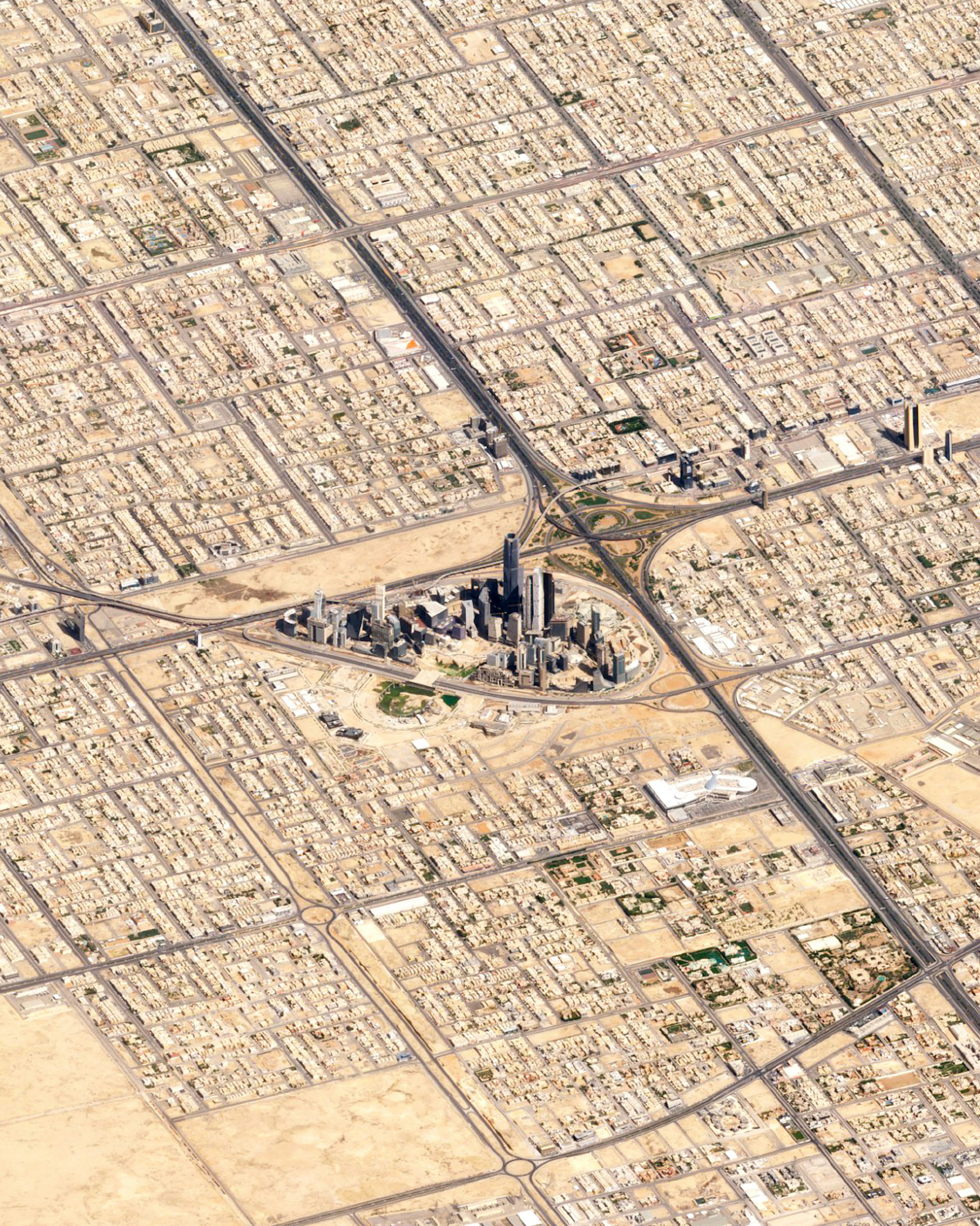
Riyadh Low-Angle
24.633333°,46.716667° - Planet
Check out this amazing, low-angle view of Riyadh, Saudi Arabia. Riyadh is Saudi Arabia’s capital and most populous city, with more than 7.6 million residents. At the center of this Overview is the King Abdullah Financial District, a $10 billion development project that began in 2006 and is still under construction.