Daily
One regular dose of Earth from above
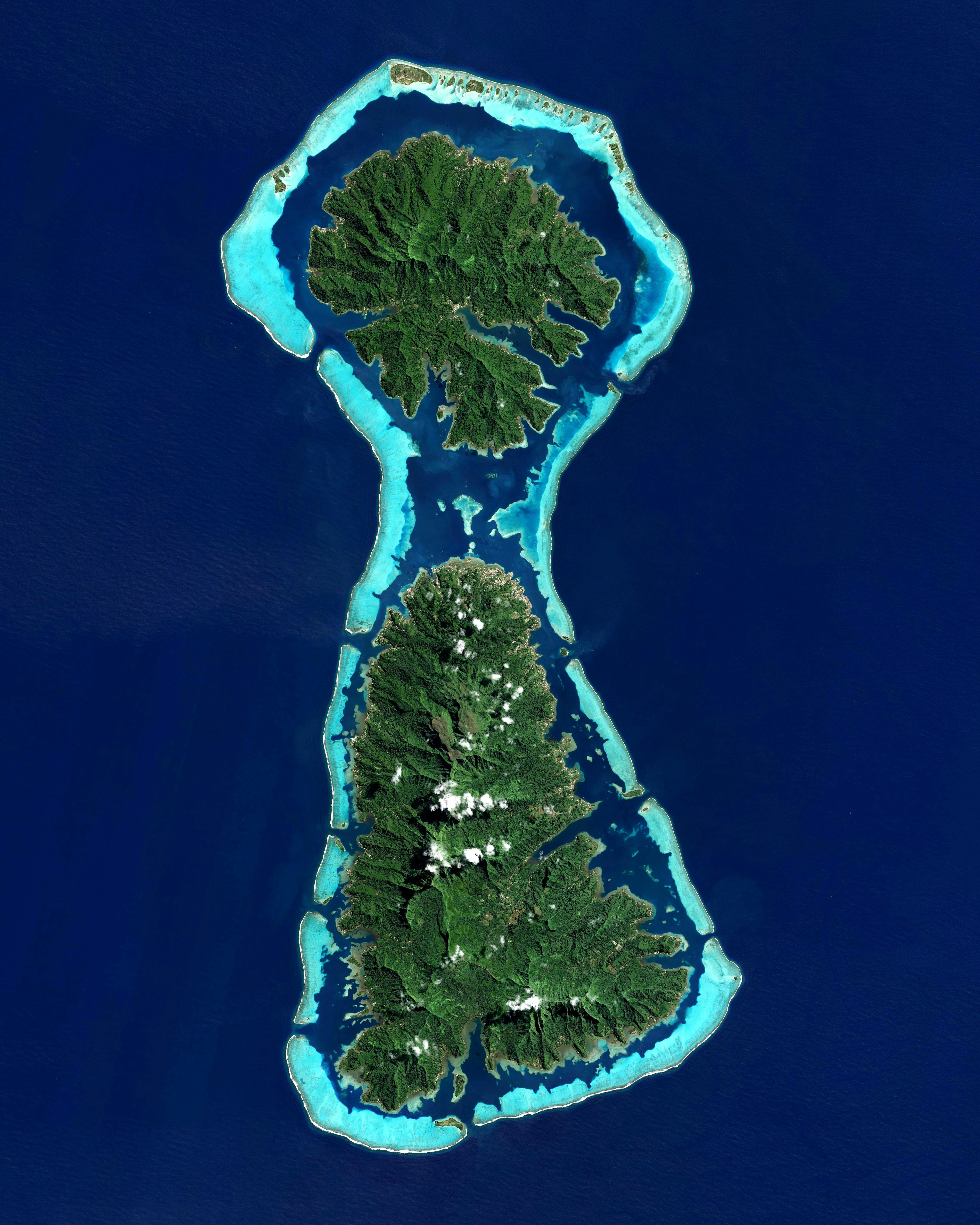
Taha'a and Raiatea
-16.816667°,-151.450000° - Airbus Space
The French Polynesian islands of Taha’a (top) and Raiatea (bottom) form a keyhole shape in the South Pacific Ocean. The two islands are enclosed by the same coral reef and may once have been a single landmass. Taha’a has a population of roughly 5,200 and Raiatea is home to about 12,500 people.
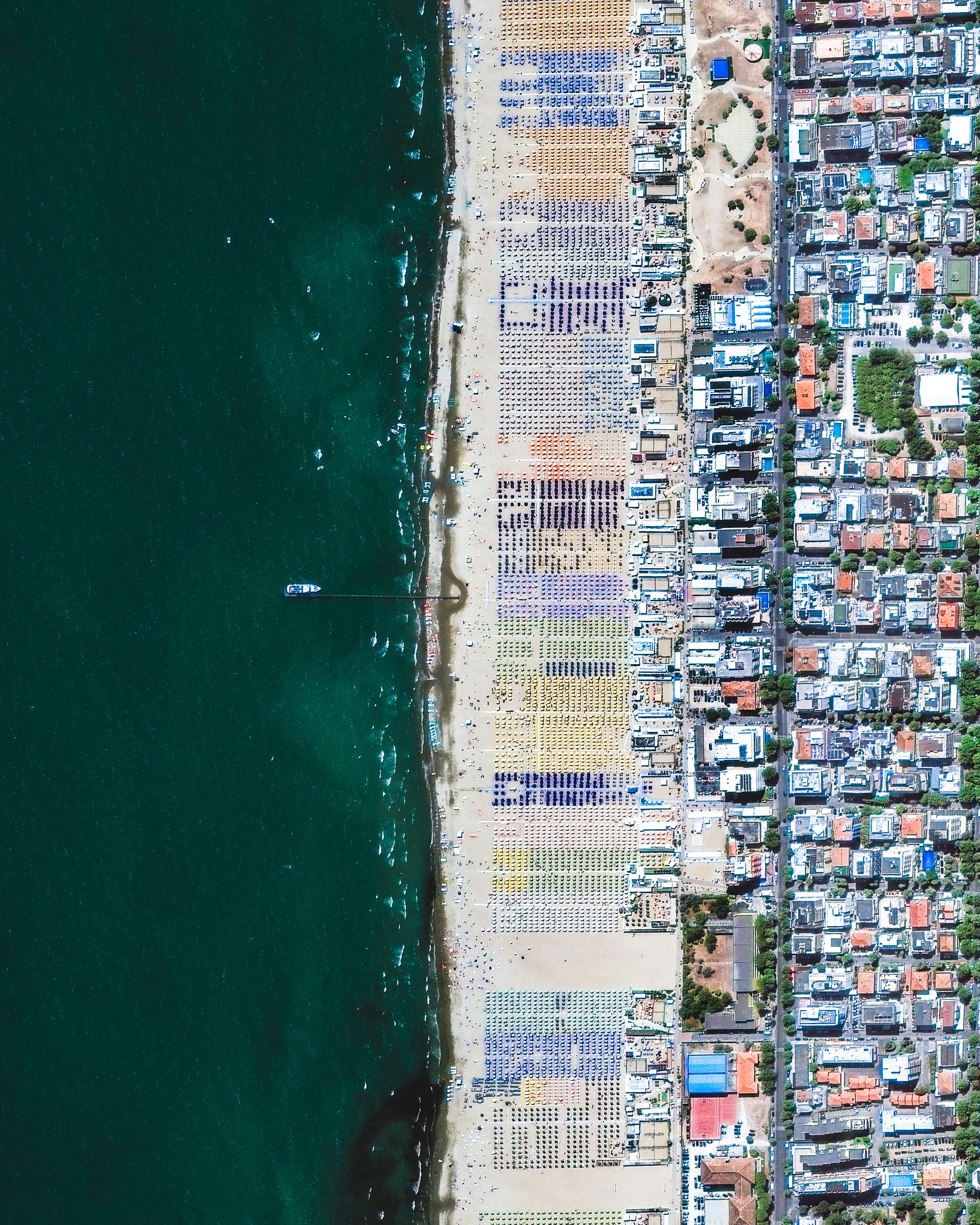
Rimini Beach Umbrellas
44.064972°,12.586833° - Maxar
Beach chairs and parasols dot the shoreline of Rimini Beach, in northern Italy. Located on the Adriatic Sea, Rimini is a city of roughly 150,000 people and is one of the most famous seaside resorts in Europe. Its 9-mile-long (14.5-km) sandy beach is surrounded by more than 1,000 hotels and thousands of bars, clubs and restaurants.
Iguazu Falls Surge
-25.695306°,-54.436735° - Maxar
Iguazu Falls, located on the Argentina-Brazil border, is experiencing a flow 10 times greater than usual after heavy rainfall in the region. With 275 cascades, the world’s largest waterfall system has a normal flow rate of 396,258 gallons of water per second. Last week, more than 3.8 million gallons per second were measured surging over the falls.
Veluwemeer Aqueduct
52.360887°,5.618397° - Floris Photography
Check out this shot of the Veluwemeer Aqueduct in Harderwijk, Netherlands. The 82-foot-long (32-meter), 10-foot-deep (3-meter) water bridge allows small watercraft to pass over the four-lane N302 motorway below. Both the aqueduct and the roadway have pedestrian crossings.
Mount Taranaki
-39.297166°,174.063228° - Maxar
Mount Taranaki is an active stratovolcano on the west coast of New Zealand’s North Island. A change in vegetation is sharply delineated between the protected national forest that encircles the volcano and the surrounding land comprised of intensively-farmed dairy pastures. Taranaki is 8,260 feet (2,518 meters) in elevation.
Goodyear Stack Interchange
33.461538°,-112.427498° - Nearmap
A stack interchange at the junction of Interstate 10 and Loop 303 in Goodyear, Arizona was constructed between 2012 and 2017. The $147 million project aims to improve access to the city of Goodyear and the broader "West Valley" of Arizona, in hopes of attracting manufacturing and other industries to the region. Loop 303 serves the western Phoenix metropolitan area, and Interstate 10 runs 2,460 miles (3,959 km) from California to Florida.
South Georgia Island
-54.400000°,-36.700000° - Maxar
Clouds blanket the coastline of South Georgia Island, a British Overseas Territory in the South Atlantic Ocean. The island has no tree cover and is mountainous, with a central ridge and many fjords and bays along its coast. King Edward Point, a British Antarctic Survey research station, serves as the island’s capital and main settlement, with a population of about 20 people.
Crimean Bridge Explosion
45.308600°,36.506100° - Maxar
An explosion this morning destroyed sections of the Kerch Strait Bridge, which connects the Russian-occupied Crimean Peninsula to Russia. The 13-mile (21-kilometer) structure is the only bridge to cross the strait and has served as an important supply route for Russian troops fighting in southern Ukraine. This Overview shows collapsed sections of road and flames coming from a train on the bridge’s railroad section.
Fort Myers Beach Mobile Homes
26.447413°,-81.936657° - Nearmap
Mobile homes in Fort Myers Beach, Florida were picked up and carried away by the storm surge of Hurricane Ian. The floodwaters, which likely exceeded 6 feet (1.8 meters) in this area, were accompanied by damaging wind gusts of up to 155 mph (250 km/h). Incredibly, some residents rode out the storm in their mobile homes and survived.
Oktoberfest in Munich
48.132168°,11.550149° - Maxar
Today is the final day of Oktoberfest, an annual, two-week festival held in Munich, Germany. More than 6 million people attended this year’s festival, which returned after a two-year hiatus due to COVID-19. The festival comes to life in the Theresienwiese, Munich’s largest fairground at 4.5 million square feet (420,000 square meters).
Wreckage in Fort Myers
26.455090°,-81.950647° - Greg Lovett, The Palm Beach Post / USA Today Network
A large pile of boats and other wreckage near Fort Myers Beach, Florida, sits mangled in the wake of Hurricane Ian. The entire Fort Myers metropolitan area, home to upwards of 750,000, suffered catastrophic damage in the storm, which is the fifth-strongest to ever hit the contiguous United States. Early estimates place the total cost of damages throughout Florida at $40 billion.
Traffic Jams Flee Russia
42.783321°,44.633499° - Maxar
Long lines and traffic jams have formed at Russian ports of exit as thousands flee the country to avoid being drafted into the war in Ukraine. This Overview shows a line of traffic near Russia’s border with Georgia, which stretched for nearly 10 miles (16 kilometers). The exodus began several days ago, when Russian President Putin announced a mobilization of 300,000 reservists into war.
Port of Los Angeles
33.731097°,-118.248826° - Nearmap
Cargo ships dock at one of the many shipping container terminals in the Port of Los Angeles, California. Also known as “America's Port,” it has been the busiest container port in the United States for at least 20 consecutive years, handling 9.2 million twenty-foot equivalent units (TEUs) of cargo in 2020. The port handles 20% of all incoming cargo for the USA.
Calgary
51.045833°,-114.057500° - Planet
Calgary is the third-largest city in Canada and largest in the province of Alberta, with about 1.4 million inhabitants. The city is located at the transition of the Canadian Rockies foothills and the Canadian Prairies, serving as a popular base for adventure-seekers venturing into the four Canadian Rocky Mountain Parks. Calgary’s city center sits at the confluence of the Bow and Elbow Rivers.
Azadi Tower
35.699444°,51.337778° - Maxar
Thousands of activists have gathered in Tehran, Iran recently to protest the death of a young woman detained by the country’s “morality police.” The 22-year-old woman died last week after being arrested for not complying with Iran’s strict rules on head coverings for women. This Overview shows Azadi Tower in Tehran, which became a symbol of freedom during the Iranian Revolution in 1979.
Windsor Castle
51.483333°,-0.604167° - Maxar
Today, Queen Elizabeth II was buried at Windsor Castle, in the English county of Berkshire. She was interred at St. George’s Chapel alongside her husband, Prince Philip, following a state funeral at Westminster Abbey and a procession across central London. Windsor was her majesty’s primary residence as a princess during World War II, her preferred weekend destination throughout her reign, and a refuge during the pandemic.
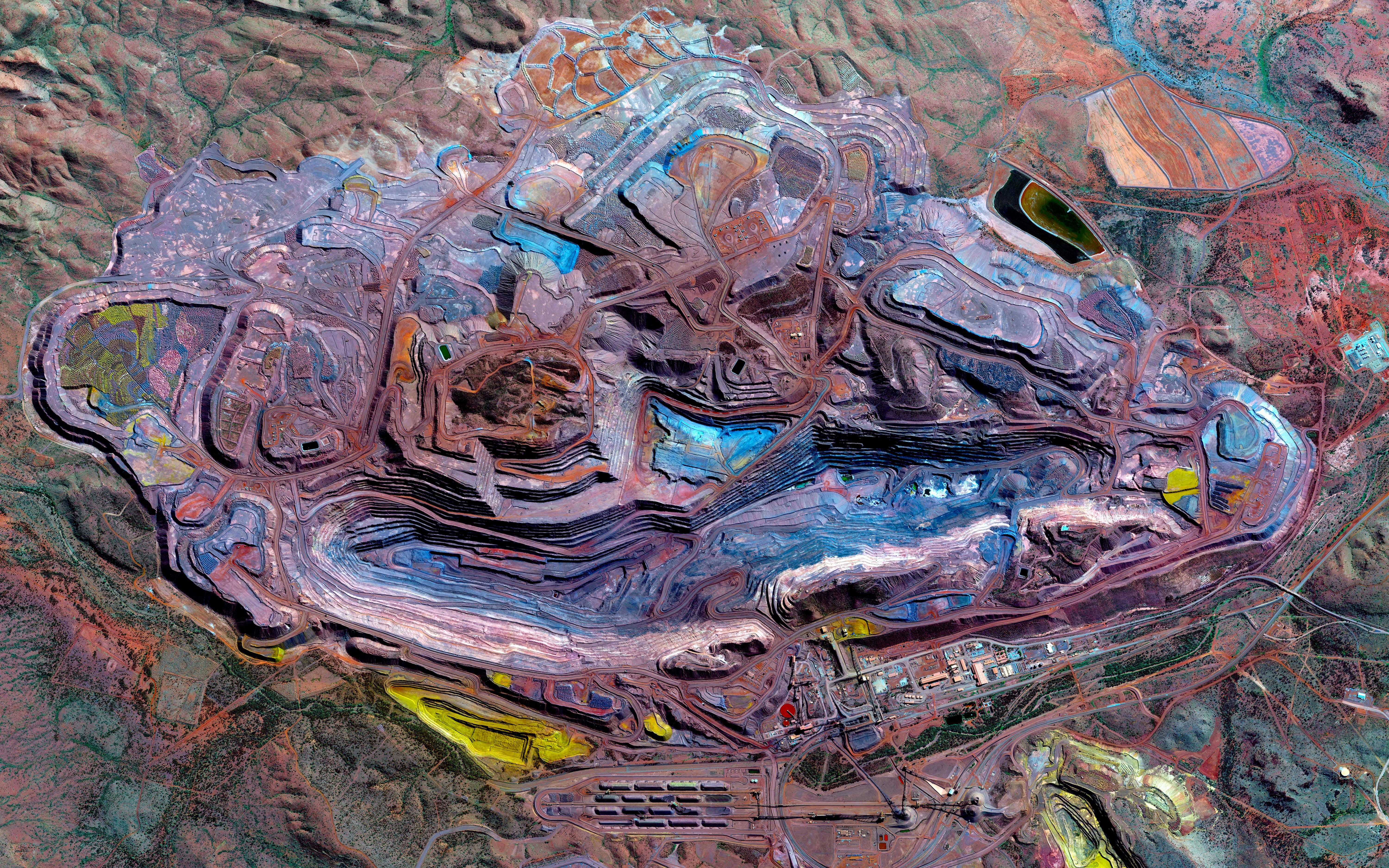
Mount Whaleback Iron Ore Mine
-23.365360°,119.675400° - Maxar
The Mount Whaleback Iron Ore Mine is located in the Pilbara region of Western Australia. It measures nearly 1 mile (1.5 kilometers) wide and more than 3 miles (5 kilometers) long. Nearly all of mined iron ore is used to make steel, and it is thus a major component in the construction of buildings, automobiles, and appliances such as refrigerators.
Etna
37.755000°,14.995000° - Planet
Smoke rises from Mount Etna, an active stratovolcano on the east coast of Sicily, Italy. At 11,014 feet (3,357 meters), it is one of the tallest active volcanoes in Europe. Over a six-month period in 2021, Etna erupted so much volcanic material that its height increased by approximately 100 ft (30 m).
Qarhan Playa
36.826290°,95.273682° - Google Timelapse
Numerous saltwater evaporation ponds have been built in China’s Qarhan Playa since the early 1990s. Located in Qinghai Province, Qarhan was once a single unitary lake and is now an expansive salt flat covering 2,261 square miles (5,856 square km). It is heavily exploited for its valuable reserves of salt, potash, lithium, iodine and other minerals.
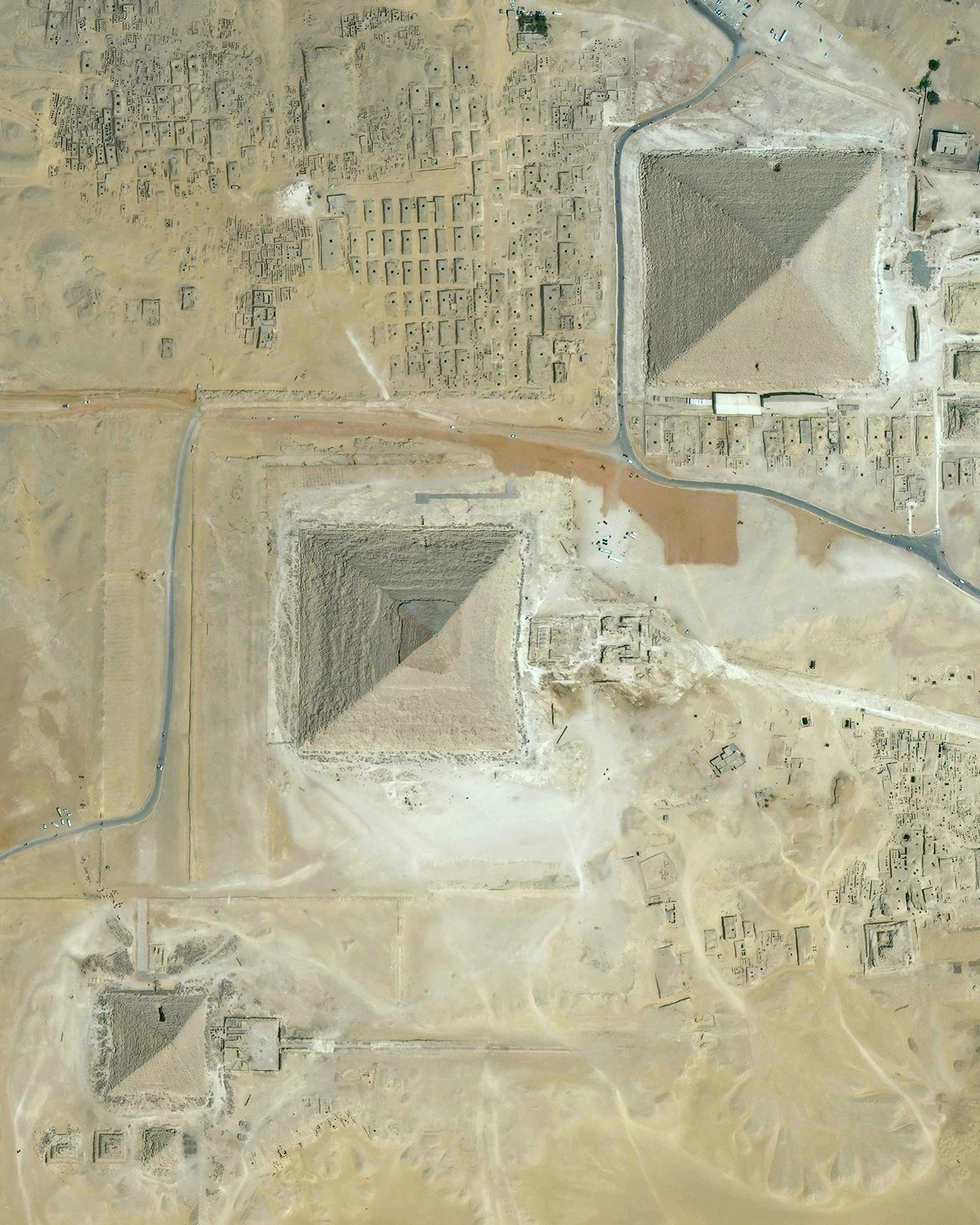
Great Pyramids of Giza
29.979234°,31.134201° - Maxar
The Great Pyramids of Giza are located on the outskirts of Cairo, Egypt. Dating back to 2580 BC, the Great Pyramid, the largest structure at the site, is the oldest of the Seven Wonders of the Ancient World and the only one to remain largely intact. With an estimated 2.3 million stone blocks weighing 2 to 30 tons each, the 481-foot-tall (146-meter) pyramid was the tallest structure in the world for more than 3,800 years.


