Daily
One regular dose of Earth from above
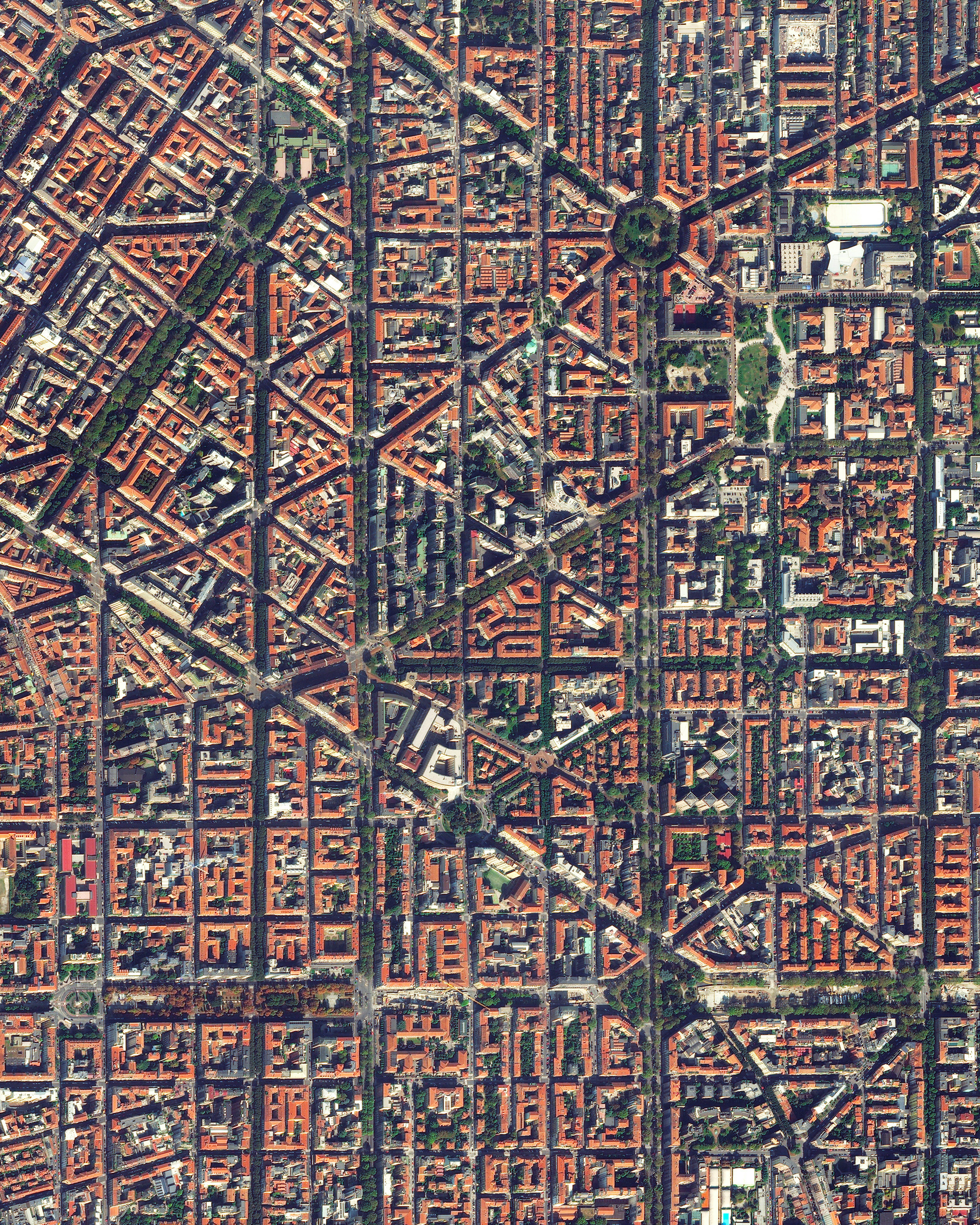
Milan
45.466944°,9.190000° - Maxar
Milan is a major city in northern Italy, with more than 3.1 million people living in its metropolitan area. The city is considered one of the world's four fashion capitals (along with London, New York, and Paris) thanks to several international events and fairs, including Milan Fashion Week. This Overview focuses on the eastern side of Milan, cross-crossed by wide boulevards that come together at large, open squares called “piazzali.”Read the full story →
Ushuaia
-54.801944°,-68.303056° - Maxar
Ushuaia, Argentina, is nestled between the Martial Mountains and the Beagle Channel near the southernmost tip of South America. Nicknamed “The End of the World,” the city of roughly 75,000 people is 680 miles (1,100 km) from the Antarctic Peninsula. Seen in these Overviews is Ushuaia – Malvinas Argentinas International Airport, the world’s southernmost international airport.
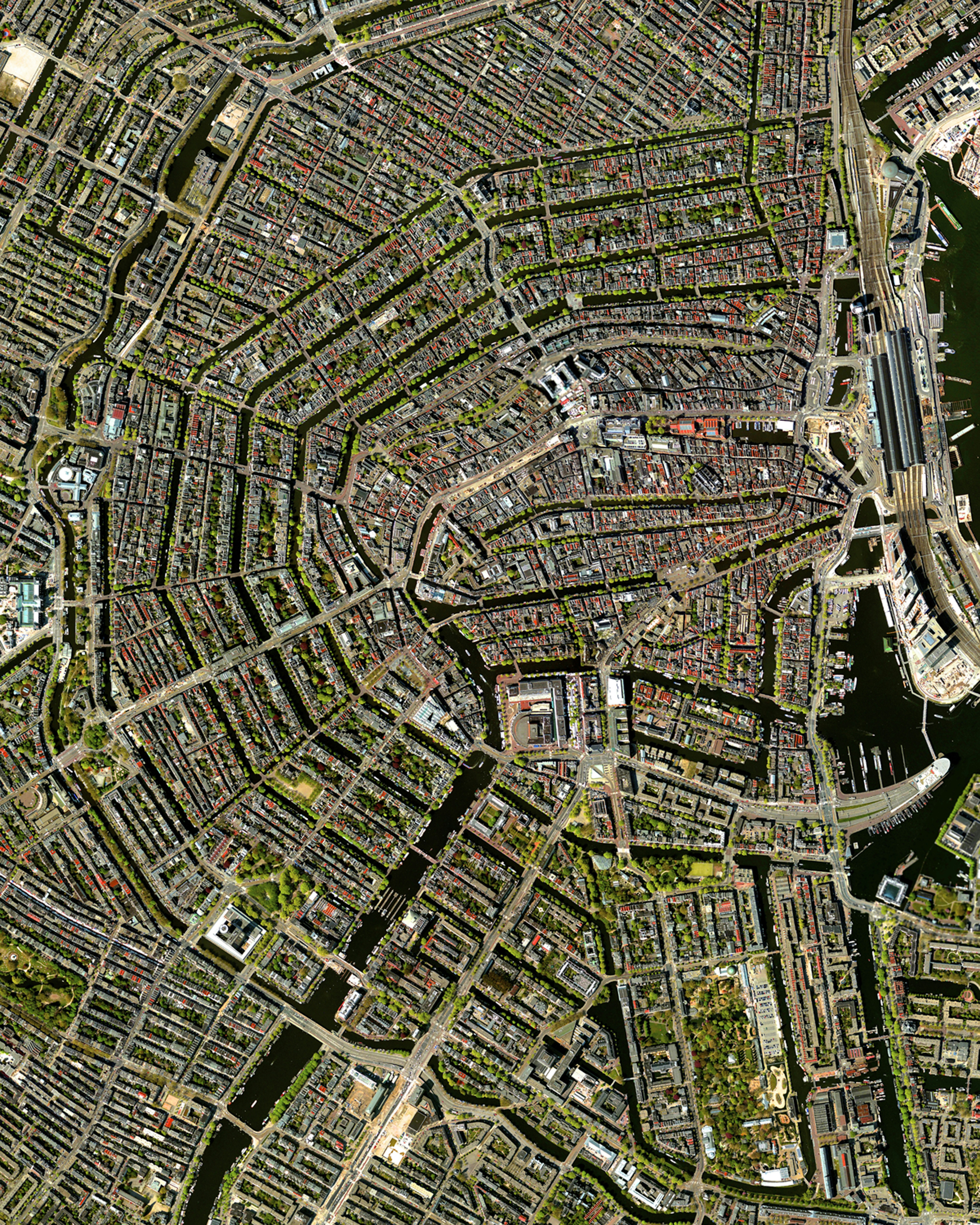
Amsterdam
52.366667°,4.900000° - Maxar
This Overview details the canal system of Amsterdam — known as “Grachten.” In the early 17th century, when immigration was at a peak, a comprehensive plan for the city’s expansion was developed with four concentric half-circles of canals emerging at the main waterfront (seen on the right-hand side of this Overview). In the centuries since, the canals have been used for defense, water management, and transport. They remain a hallmark of the city to this day.
Queensland Bauxite Mining
-12.629800°,141.878100° - Google Timelapse
Weipa Town, in Far North Queensland, Australia, has seen a steady growth of bauxite mining in recent decades. Bauxite, the main raw material used to make aluminum, is surface mined using bulldozers and scrapers and the removed topsoil is stored for later revegetating and restoration. Since 1963, mines around Weipa have produced about 34 million metric tons of bauxite.
Angkor Wat
13.412500°,103.866667° - Maxar
Angkor Wat is a temple complex in Cambodia that is the largest religious monument in the world — first it was Hindu, then Buddhist. Constructed in the 12th century, the 820,000-square-meter site features a moat and forest that harmoniously surround a massive temple at its center.
Dasht-e Kavir
34.797689°,54.728858° - Planet
Dasht-e Kavir is a large desert in the middle of the Iranian Plateau. Spanning roughly 30,000 square miles (77,600 square kilometers), temperatures in the “Great Salt Desert” can soar up to 122°F (50°C), causing extreme vaporization that turns marshes and mud grounds into swirling crusts of salt, as seen in this segment of the desert here.
Grand Ethiopian Renaissance Dam
11.212896°,35.094475° - Planet
The Grand Ethiopian Renaissance Dam, located on the Blue Nile River in Ethiopia, has been under construction since 2011 and is expected to be complete in 2023. It impounds the Millennium Reservoir, which has been filling since 2020, and will harness hydroelectricity to bring power to nearly half of Ethiopians. The dam has created controversy with downriver countries like Sudan and Egypt, who are concerned about drought as the reservoir is rapidly filled.
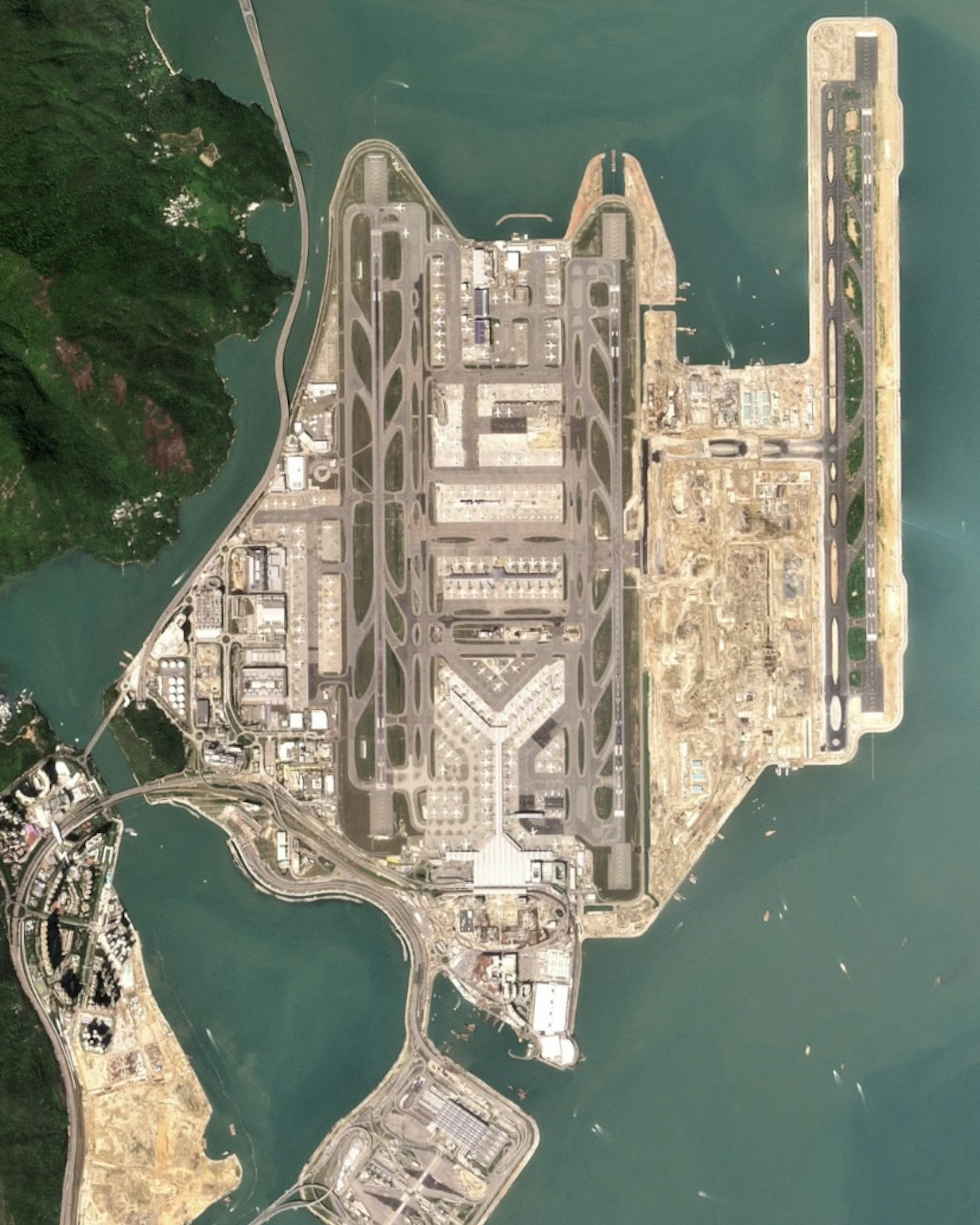
Hong Kong International Airport
22.308047°,113.918480° - Planet
Construction of Hong Kong International Airport began in 1991 on 12.5-square kilometers (4.85 square miles) of reclaimed land and took seven years to complete. An additional 6.5 square kilometers (2.5 square miles) is now being added to construct a third runway, scheduled for completion in 2024. Hong Kong is one of the world’s busiest passenger airports, handling upwards of 70 million people a year.
Florida Keys
24.666944°,-81.544167° - Planet
The Florida Keys are a string of tropical islands stretching about 120 miles (193 km) off the southern tip of the U.S. state of Florida, between the Atlantic Ocean and Gulf of Mexico. Forty-two bridges connect 800 keys in total, the longest of which, Seven Mile Bridge, links all keys back to the Florida mainland. This Overview focuses on several inhabited keys, including Big Pine Key, Summerland Key, Cudjoe Key and Little Torch Key, among others.
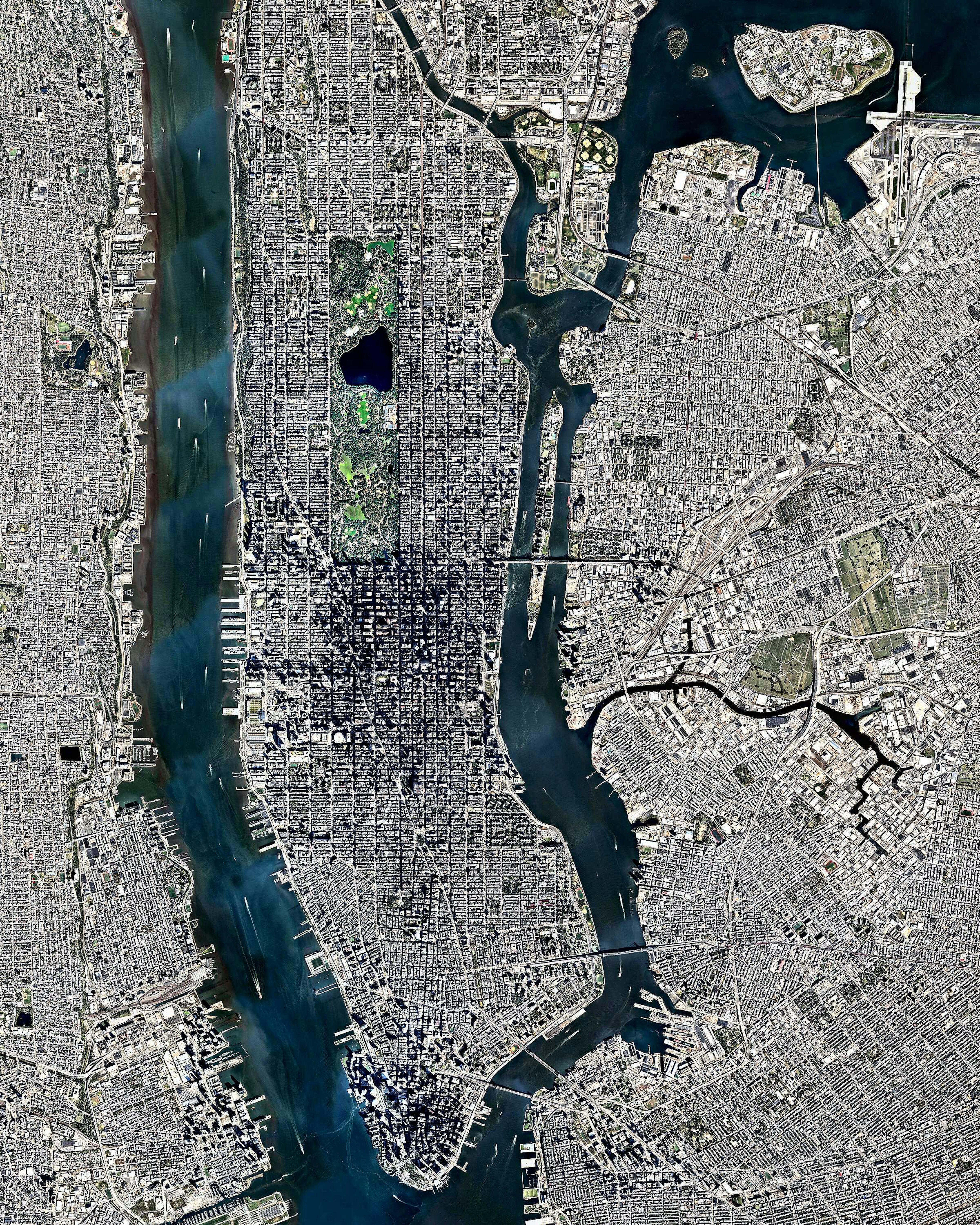
Manhattan
40.758977°,-74.108972° - Nearmap
Manhattan, seen at center, is the most densely populated borough in New York City and is home to roughly 1.6 million people. With an area of nearly 23 square miles, more than 72,000 people live in every square mile. If the entire world lived with this population density, all of humanity could fit into the country of New Zealand.
Adventuredome
36.138056°,-115.167389° - Nearmap
Adventuredome is a five-acre indoor amusement park on the Las Vegas Strip in Nevada, USA. The facility's main structure consists of more than 350,000 square feet of pink insulated glass. Inside are two roller coasters, a water ride, rock climbing wall, 18-hole miniature golf course and dozens of carnival games.
Nigeria Floods
7.500000°,6.700000° - Maxar
Since early summer 2022, intense floods have inundated Nigeria, damaging over 200,000 homes and displacing nearly 1.5 million people. Nigeria experiences regular seasonal flooding, but this year’s disaster has been attributed to heavy rain and climate change. This Overview shows the effects of flooding on a village in Kogi State.
Jatayu Earth Center
8.865885°,76.867261° - Maxar
Jatayu Earth Center, a park and tourism center in Kerala, southern India, boasts the world’s largest bird sculpture. Measuring 200 feet (61 m) long, 150 feet (46 m) wide and 70 feet (21 m) tall, it depicts Jatayu, a Hindu demi-god who took the form of a vulture. According to legend, Jatayu had one wing chopped off while attempting to save a kidnapped princess, which is why the sculpture only has one wing.
Rome
41.893333°,12.482778° - Airbus Space
Rome is the capital and most populous city of Italy, with upwards of 2.8 million inhabitants. Situated along the Tiber River, it has been an important religious, artistic and cultural hub for thousands of years and is generally considered the “cradle of Western civilization.” Also shown in this Overview is Vatican City, the smallest country in the world, located inside the Rome’s city boundaries.
Rolim de Maura Deforestation
-11.725339°,-61.818031° - Google Timelapse
Here’s roughly 4,100 square kilometers (1,600 sq. mi) of deforestation around Rolim de Moura, Brazil. This community, like many in Brazil’s state of Rondônia, has grown since the 1980s, when the government incentivized farmers to resettle here from more crowded areas in the south. In 1985, less than 10% of Rondônia was deforested for farming; but by 2017, 33% of its forested land had been converted to pasture and agriculture.
San Michele Island
45.447000°,12.347000° - Maxar
San Michele is an island in the Venetian Lagoon of northern Italy. It was declared an official cemetery by Napoleon in 1837 and is solely occupied by tombs and chapels. Among those buried on San Michele are composer Igor Stravinsky, poet Ezra Pound, physicist Christian Doppler, and Russian Princess Catherine Bagration.
International City Dubai
25.167111°,55.403250° - Maxar
International City is a neighborhood in Dubai, UAE, with numerous country-themed residences, business and tourist attractions. It currently has 10 country “clusters” inspired by China, England, France, Persia, Greece, Russia, Spain, Italy, Morocco and the Emirates. The arrangement of the city is inspired by traditional carpets of the Middle East.
Amazon Rainforest Clouds
-2.513200°,-61.712400° - Maxar
Clouds float over the Amazon Rainforest 120 miles (193 km) outside of Manaus, Brazil. This particular location lies within the Rio Negro State Park North Section, a more than 360,000-acre (146,000-hectare) protected area of which 87% is classified as dense rainforest. About 30 families live in the park; most are descendants of indigenous groups who make a living growing crops like bananas and cassava.
Statue of Unity
21.838000°,73.719100° - Maxar
The Statue of Unity, in Gujarat, India, is the world's tallest statue at a height of 597 feet (182 meters). Located on the Namarda River just south of Sardar Sarovar Dam, it depicts Indian statesman and independence activist Vallabhbhai Patel, who was the first deputy prime minister of independent India. With its 190-foot (58-meter) base, the Statue of Unity is more than 2.5 times as tall as the Statue of Liberty in New York City.
Bilbao
43.263147°,-2.935258° - Maxar
Bilbao is a city of about 350,000 people in the Basque Country of northern Spain. Its urban center, seen here along the River Nervión, features a grid of rectangular buildings and wide avenues, which is based on a similar design used in Barcelona. Within this Overview is the Doña Casilda Iturrizar public park, Guggenheim Bilbao museum and the Abando Indalecio Prieto railway station, Bilbao’s central station.


